Chapter 10: Typical Weather
 |
| An October low centered over the Great Lakes with a warm front that has already passed over the AICW and a cold front that's on its way. This was a record-breaking storm bringing strong winds, thunderstorms, and tornadoes to a large swath of the Midwest (NOAA GOES Project, taken at 4:32 PM CDT on October 26, 2010). |
10. Typical Weather Patterns on the ICW
Introduction
So what kind of weather can you expect during your ICW cruise? There are two distinct seasonal weather patterns in the Southeast US: winter weather (November through April) and summer weather (May through October). Thunderstorms feature prominently in both patterns, but for different reasons.
Thunderstorms can occur along the ICW during any month of the year. When we think about the dangers posed by thunderstorms, most people immediately think of the risk of a lightning strike. Although lightning is a serious hazard, the most serious risk posed by thunderstorms is wind. In a thunderstorm, your chances of being struck by lightning are really low. In contrast, your likelihood of being struck by strong wind is nearly 100%. The winds associated with a thunderstorm will pick up and shift direction suddenly, and with little warning. It’s important to anticipate this wind and take action to prepare for it by reducing sail, battening-down the boat, getting into sheltered waters, and/or tying up to a dock or dropping an anchor. Once the strong winds start blowing it’s very difficult to take any of these actions, so get prepared before the storm arrives.
The winter pattern is dominated by the frequent passage of fronts. Summer weather can be a bit more varied, featuring pop-up thunderstorms, the occasional passage of fronts, and tropical cyclones.
 |
| Janet and Loki guiding the boat through the Rock Pile (MM 350) on a drizzly day. (She's holding the tiller behind her.) |
Winter Weather Pattern
From mid-fall to mid-spring (November through April), the winds on the ICW are almost continuously veering, which is also called “clocking.” That is, if you stand in one location and note the wind direction every hour for a week or more, you’ll discover that over time, the winds keep shifting around in a clockwise direction. If the wind is blowing out of the north, at some point soon it will shift to the northeast, then the east, southeast, south, southwest, west and so on. And for the most part, it will keep rotating in this clockwise direction for months on end. The opposite of clocking/veering is called backing. Don’t confuse “clocking,” or the clockwise shifting of the wind over time, with the clockwise circulation of wind around a zone of high atmospheric pressure. These are two different things. In fact, as a low-pressure system passes to your north, the wind will veer, shifting in a clockwise direction over time, even though the wind is circulating around the low pressure center in a counterclockwise direction.
The cloud formations of these winter low-pressure systems, as seen in satellite images, look like giant commas. The round dot at the top of the comma is the low-pressure center. There is a tail of cloudiness that runs southward from the center of low pressure, and the lower part of this tail usually bends off a bit to the west. The trailing edge of the tail (the western and northern edges) is the cold front. There is usually a fainter tail that extends toward the east from the center of low pressure. This tail is usually less obvious from satellite imagery, but this is the warm front. If the two tails seem to overlap partially, which will be close to the center of the low pressure, this is an occluded front, which can cause very violent weather.
 |
| A classic nor'easter hitting New England. The warm front is extending off to the east and the cold front spirals to the south and southwest. The fronts appear to be occluded to the east and southeast of the eye-like center. (NOAA GOES-16 satellite, 13:15 UTC, May 13, 2018). |
The reason why the pattern of winter weather is so consistent in the Deep South is because the low-pressure centers almost always stay north of this region. But the trailing fronts can extend southward for well over a thousand miles. If you are in this region, what you primarily experience is the passage of the fronts rather than the low-pressure center itself. So, as one of these weather systems tracks generally from west to east (or southwest to northeast), the cold front sweeps over all of the southern states, the Gulf of Mexico, and the Bahamas. So we are continually going through a cycle of:
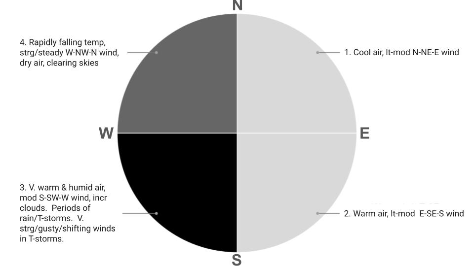
1. Being between two low-pressure systems and their associated warm and cold fronts. One system is moving away to the east while the other is approaching from the west (wind at your location is light & clocking N - NE - E, cool temperature)2. Warm front approaching from the west (light wind E - SE), and this warm front passes by and continues moving away toward the east (moderate wind SE - S, temperature and humidity rising)3. Cold front approaches from the west (light - moderate wind S - SW - W, high temperature and humidity; showers and thunderstorms; wind becomes strong, gusty and shifty in thunderstorms), and4.Cold front passes by and moves away toward the east (strong wind W - NW - N, skies clearing, temperature plummeting).
Then the cycle repeats.
This winter weather pattern of clocking winds associated with the passage of fronts usually takes 2 to 7 days to complete a full 360-degree rotation. Occasional disruptions of this clocking pattern can take place. It doesn’t happen much but the wind can back for short periods. This can happen for a few reasons: (1) when two low-pressure systems pass by in rapid succession, (2) when high pressure becomes established and there is a very long period between successive low-pressure systems, or (3) when a low-pressure center passes to the south of your location. When two systems are close to another, meaning that the two cold fronts are within about 2 days of each other, there is a rapid transition between the exit of the first cold front and the arrival of the next warm front. This can cause a “resetting” of the clock, in which the wind jumps back in a counterclockwise shift and then continues clocking from this new starting point. When there is a long period of time between successive cold fronts (more than ~5 days), meaning that there is a large geographic area between these frontal systems, the wind between these systems can meander within the range of NE-E-SE-S-SW before resuming its clocking pattern with the arrival of the next warm front. When an area of low pressure passes to your south, you experience the counterclockwise winds in the top half of the clock. Since the storm is passing south of you and moving from west to east, you would first experience winds from a southeasterly direction and they would back to the northeast and then the northwest as the low passed by. A storm that does this is called a nor'easter, and this scenario happens more on the ICW during winters when El Niňo conditions exist (as opposed to neutral or La Niňa).
There are relatively consistent, predictable changes in weather that occur as the wind clocks around, such that if you tell an experienced mariner any one of the three following pieces of information: wind speed, wind direction, or non-wind-related weather conditions (cloud cover, precipitation, temperature, and humidity), they’ll be able to make an educated prediction about the other two. Furthermore, they’ll be able to predict likely conditions for the next couple of days. For example, if the wind is blowing out of the northwest, you know it is probably going to be a strong wind with clear, dry, cold weather and that wind will moderate over time as it shifts into the north and northeast. If the weather is very warm and humid in the winter, you know that a warm front has just passed and that you can expect to have rain and/or thunderstorms in the near future, followed by the arrival of a cold front bringing strong westerly and then northwesterly winds. During the thunderstorms that precede the cold front, you are likely to experience very strong, gusty, shifty winds. If you recognize this pattern, you will have a better understanding of weather forecasts and be able to predict the weather better, improving your safety and confidence while cruising.
A. Shade indicates relative wind speeds (darker shade = stronger wind)
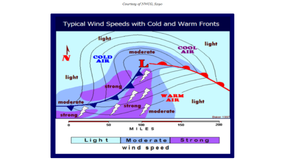 |
| Pattern of wind speeds, thunderstorms, and air temperatures associated with the warm and cold fronts trailing from low-pressure storm systems. The concentric black lines are isobars, which outline regions of equal barometric pressure. In general, winds blow roughly parallel to the isobar lines, moving counterclockwise around the center of low pressure, indicated by the “L.” |
This winter weather pattern of clocking winds associated with the passage of fronts usually takes 2 to 7 days to complete a full 360-degree rotation. Occasional disruptions of this clocking pattern can take place. It doesn’t happen much but the wind can back for short periods. This can happen for a few reasons: (1) when two low-pressure systems pass by in rapid succession, (2) when high pressure becomes established and there is a very long period between successive low-pressure systems, or (3) when a low-pressure center passes to the south of your location. When two systems are close to another, meaning that the two cold fronts are within about 2 days of each other, there is a rapid transition between the exit of the first cold front and the arrival of the next warm front. This can cause a “resetting” of the clock, in which the wind jumps back in a counterclockwise shift and then continues clocking from this new starting point. When there is a long period of time between successive cold fronts (more than ~5 days), meaning that there is a large geographic area between these frontal systems, the wind between these systems can meander within the range of NE-E-SE-S-SW before resuming its clocking pattern with the arrival of the next warm front. When an area of low pressure passes to your south, you experience the counterclockwise winds in the top half of the clock. Since the storm is passing south of you and moving from west to east, you would first experience winds from a southeasterly direction and they would back to the northeast and then the northwest as the low passed by. A storm that does this is called a nor'easter, and this scenario happens more on the ICW during winters when El Niňo conditions exist (as opposed to neutral or La Niňa).
There are relatively consistent, predictable changes in weather that occur as the wind clocks around, such that if you tell an experienced mariner any one of the three following pieces of information: wind speed, wind direction, or non-wind-related weather conditions (cloud cover, precipitation, temperature, and humidity), they’ll be able to make an educated prediction about the other two. Furthermore, they’ll be able to predict likely conditions for the next couple of days. For example, if the wind is blowing out of the northwest, you know it is probably going to be a strong wind with clear, dry, cold weather and that wind will moderate over time as it shifts into the north and northeast. If the weather is very warm and humid in the winter, you know that a warm front has just passed and that you can expect to have rain and/or thunderstorms in the near future, followed by the arrival of a cold front bringing strong westerly and then northwesterly winds. During the thunderstorms that precede the cold front, you are likely to experience very strong, gusty, shifty winds. If you recognize this pattern, you will have a better understanding of weather forecasts and be able to predict the weather better, improving your safety and confidence while cruising.
A. Shade indicates relative wind speeds (darker shade = stronger wind)
B. Colors indicate relative temperatures (red is warmest, blue is coldest)
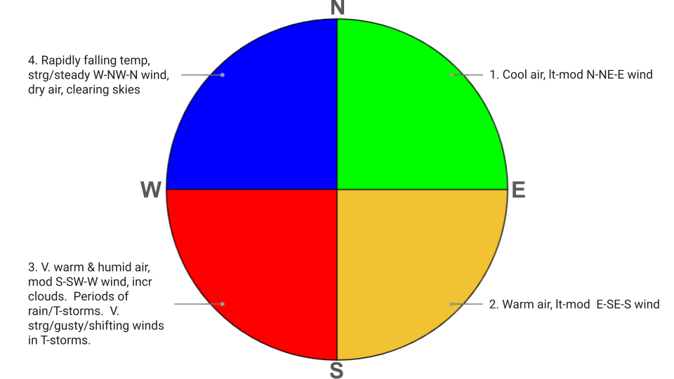 |
| Typical pattern of wintertime weather in the Southeast U.S. The cardinal directions (N, E, S & W) represent the direction of the gradient winds (i.e., the direction from which the wind is blowing). The color tone in panel A represents relative wind speed with white showing calm winds and black indicating very strong winds. (Gale force is common and can be up to hurricane force) The color scale in panel B represents relative air temperature, with dark blue being the coldest and red the warmest. Transitions are made from one stage (pie slice) to the next in a clockwise manner, as indicated by the numbers. During stage 1, the cold front from one low-pressure system is moving away while the warm front from the next low-pressure system approaches. In Stage 2, the warm front passes. In stage 3, a squall line passes through. This squall line precedes the cold front. By the beginning of stage 4, the cold front has passed and cold air rushes in behind the front. These stages vary in duration. Advancing through all 4 stages shown above usually takes 2 to 7 days. Every weather system is unique, so expect some deviations from this idealized pattern. On average, however, this is an accurate depiction of the winter weather pattern in the southeastern U.S. (v. = very, lt = light, mod = moderate, strg = strong, incr = increasing, T-storm = thunderstorm, temp = temperature). |
The figure below is a NOAA marine weather forecast for the waters off the south coast of Georgia. It shows the winds clocking from southeast to northwest over a period of roughly 4.5 days.
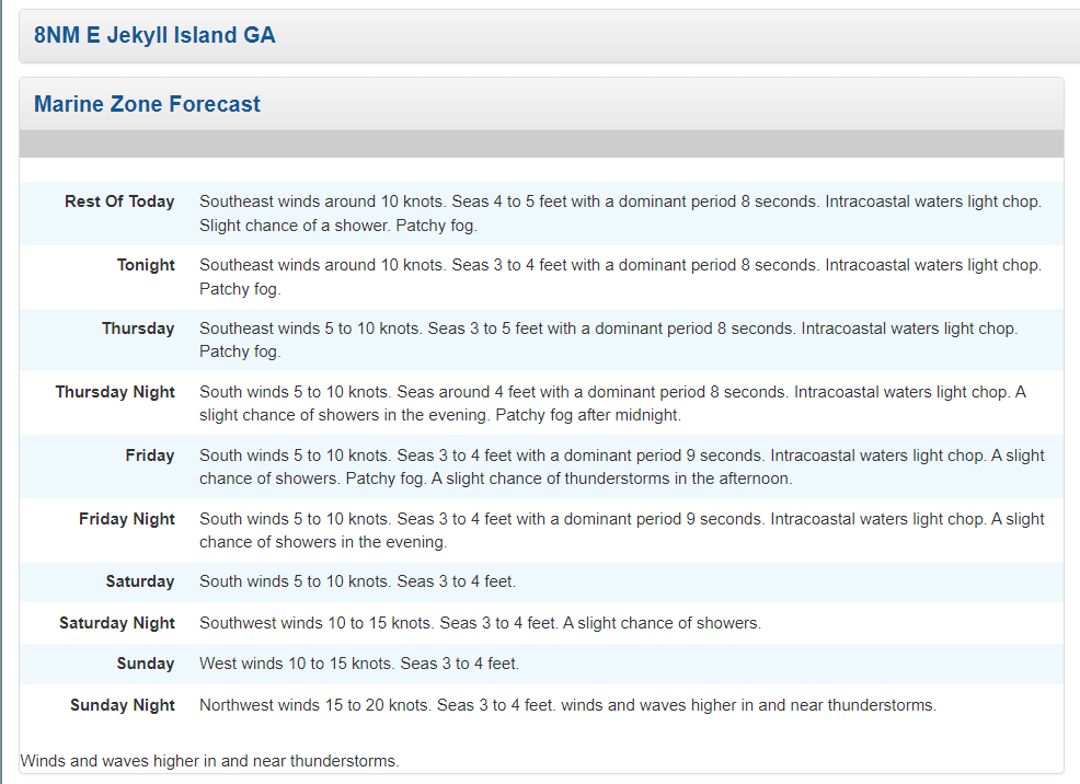 |
| Marine forecast from NOAA’s National Weather Service for the coastal waters from Altamaha Sound, GA to Fernandina Beach, FL, out to 20 nm for Wednesday, January 24, 2024 (source: https://www.weather.gov/jax/). |
Whenever you see the winds clocking, as in this example forecast, a little alarm should sound in your head because you know that there is a high probability of thunderstorms and very strong winds at some point when the gradient wind direction is between south and west. It doesn’t matter if the forecast calls for relatively moderate wind speeds or even if it neglects to mention the possibility of thunderstorms at all. Just be on high alert any time the wind clocks through sector #3 from the graphic above. This example forecast mentions the possibility of thunderstorms for Friday afternoon, but the predicted wind speeds are only 5 to 10 knots. Trust us when we say this, you are highly likely to see periods of wind MUCH higher than what is stated in the forecast whenever there are rain showers or thunderstorms taking place as the wind is clocking through sector 3. Thunderstorm cells generate their own wind (convective wind), which as we’ve already discussed, can be quite strong but are down-played in forecasts because many of the forecast models aren’t designed to predict them. Just be on-guard when the winds clock through sector 3 (and 4) and watch for those tell-tale phrases in the forecast regarding thunderstorms and wind speeds.
Do not be surprised if, soon after the cold front arrives (early in sector 4), the wind speed is a bit higher than what is forecast. In this case, the forecast is calling for northwest winds at 15 to 20 knots on Sunday night. Don’t be too surprised if the actual sustained winds are 20 to 30 knots. The wind speeds will increase rapidly at the beginning of sector 4, right behind the passing cold front (which will arrive on Sunday) and then slowly ease over time as the wind clocks into the north and then northeast.
One final note on winter weather on the ICW. Fog is not nearly as common in the Southeast U.S. as it is in the Northeast. But it still can happen in the cooler months. From October to January, morning fog is fairly common on the ICW when the wind is calm. During this time of year, the air is often colder than the water. From about January to March, we can also get fog on the ICW after the passage of a warm front, if the winds are relatively light. Fog is usually heaviest in the early morning, so sometimes the best way to deal with it is simply to enjoy another cup of coffee before getting underway.
Summer Weather Pattern
Summertime thunderstorms occur in three basic flavors: isolated pop-up storms associated with afternoon sea breezes, lines of storms associated with an advancing cold front, and storms associated with tropical disturbances. We already covered cold fronts and the thunderstorms that often precede them in the section above on wintertime weather. Cold fronts are less common in the summer, so they don’t dominate the weather during this time of year, like they do in the winter. But they do still happen. The arrival of a line of thunderstorms that are associated with a cold front is easier for forecasters to predict at any given location because they can observe the speed and motion of the cold front as it develops and evolves over time. In contrast, the precise timing and locations of pop-up storms are harder to predict. If there are thunderstorms forecasted for your area and you know that they are associated with an approaching cold front, you can almost guarantee that you are going to experience a thunderstorm. And the forecast will reflect this; with an approaching cold front, it’s common to see a forecast in which the hourly probability of thunderstorms goes from less than 10% to over 90% in just a few hours. (These hourly probabilities mean that within that 1-hour period, x% of the forecast area is expected to receive at least 0.01 inch of precipitation from thunderstorms.) In the case of pop-up storms not associated with a cold front, you’ll usually see the hourly probabilities of thunderstorms start to increase in late morning, peaking in the late afternoon or early evening. Because these pop-up storms are patchy and don’t form a continuous line, the typical probabilities of pop-up storm activity are lower than the forecast probability values of storms riding ahead of a cold front. In other words, the probability values for the occurrence of pop-up thunderstorms may be in the range of 30 to 70%, even if there is an extremely high confidence of thunderstorms developing in the area because these storms will cover a smaller percentage of the forecast area…they’re patchy or spread out. It’s pretty typical, on any given summer day in the Southeast U.S., to have daytime probabilities of thunderstorms that are in the range of 20 to 40%. That is, between the hours of 6:00 AM and 6:00 PM, 20 to 40% of the forecast area is likely to receive at least 0.01” of precipitation from a thunderstorm. With daily thunderstorm probabilities of 20 to 40%, you can expect to experience a thunderstorm every 2 to 5 days, on average. When the daily probability gets above 40%, you would consider that unstable, unsettled, stormy, or “juicy” weather, in which you are fairly likely to encounter a thunderstorm. But remember that these pop-up storms feed on heat. They are most likely to occur in the mid- to late afternoon. So a good strategy for making progress while minimizing your chances of being caught out in a thunderstorm is to get underway very early in the morning and get to your day’s destination by early afternoon.
 |
| A pop-up thunderstorm petering out over Pamlico Sound, NC, seen from Ocracoke Island. |
Of course, the summertime weather-makers that are of greatest concern to cruisers along the entire ICW are tropical cyclones, which is a catch-all term that includes tropical depressions, tropical storms, and hurricanes. Hurricane season is the most popular spectator sport among cruisers in the southern U.S. Every day from June to November, we tune into the National Hurricane Center and to other specialized marine weather forecast services like Chris Parker’s Marine Weather Center to find out where storms are likely to form in the near future, how strong they are likely to become, and where they are heading.
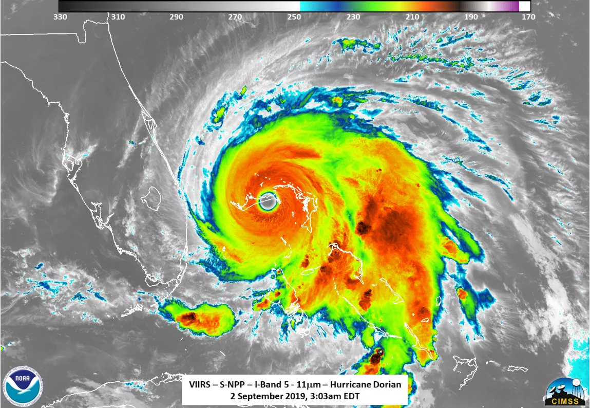 |
| Hurricane Dorian pounding the Bahamas and heading toward Florida on September 2, 2019. |
Assessing the Threat
When most people assess the potential threat of a tropical cyclone, they focus too much on the Saffir Simpson Index and on "the cone." The Saffir Simpson Index, which are those Categories 1 through 5, depends entirely on the storm's maximum sustained wind speed. Wind speed is not the only thing that determines the destructiveness of a storm. The direction from which a storm approaches the shore before landfall is very important. The more perpendicular the approach to shore, the higher the storm surge is likely to be. The shape of the coastline near the site of landfall can also promote or inhibit storm surge. If the storm enters a large embayment, such as the Georgia Bight or the Big Bend region in Florida, the surge will build higher. Also, the geographic size of the storm matters. The larger a storm is, the more water it will push ahead of it. Also, the larger and slower moving a storm is, the longer the high winds and storm surge will last.
The cone simply shows the area over which the storm's center is likely to pass. It doesn't indicate the size of the storm or how far destructive winds will extend from the storm's center. Destructive winds, storm surges, and flash floods can occur outside the cone, especially on its right side.
 |
| The forecast track, or "cone," for Hurricane Helene from the National Hurricane Center, as of the afternoon of September 26, 2024. The cone (in white) shows the area over which the storm's center is likely to pass. But as you can see from this graphic, hurricane force and tropical storm force winds extend far beyond the edge of the cone, especially on its right side. Even though the storm is in the Gulf of Mexico, tropical storm warnings extend all the way to the North Carolina-South Carolina border. (https://www.nhc.noaa.gov/) |
 |
| Storm surge flooding predictions from the National Hurricane Center for Hurricane Helene as of the afternoon September 26, 2024. Storm surge is a bulge of water pushed out ahead of the storm. The surge tends to be highest in the storm's front right quadrant (see previous figure for forecast track) and is amplified where the winds blow into an embayment. Florida's Big Bend is frequently inundated by surges from tropical cyclones for this reason. In this case, even the Georgia Bight is expecting up to 3 feet of surge, despite being far away from the hurricane's center. (https://www.nhc.noaa.gov/) |
When a hurricane begins to weaken, the peak wind speeds, which are found just outside the eye, decrease. But as these peak winds decrease in speed, the wind field expands outward, covering a larger area. Think of a figure skater spinning. Once she starts to spin, if she brings her arms in close to the center of her body, the speed of her rotation accelerates. But then when she spreads her arms horizontally out to her sides, so that they are further from the center of her body, her spin rate slows. A weakening hurricane is like that spinning skater spreading her arms out: spinning a little more slowly but covering a wider arc. Therefore a weakening hurricane can cause widespread damage; the highest wind speeds are decreasing but the wind field is growing and covering a much larger area. For a major hurricane at the peak of its strength, you might see maximum winds of 150 mph (Category 4) surrounding the eye and tropical storm force winds extending outward 100 miles from the center. As that storm weakens, you’ll see the maximum winds drop but the tropical storm force winds will reach further from the center. Maybe the maximum winds have diminished to 80 mph (Category 1) but tropical storm force winds have spread out and now extend outward for 300 miles from the storm’s center. As it continues to weaken, the wind field will continue to expand. Tropical storm force winds can still do a lot of damage. This is why you need to take action, even if you are located outside the “cone” of the forecast track or if the storm is predicted to weaken as it approaches your location.
Finally, it is good to remember that La Niňa conditions promote hurricane activity in the Atlantic. During La Niňa, when surface waters of the Eastern Tropical Pacific Ocean are cooler than normal, there is less wind shear over the Atlantic. In other words there is less variation in the speed and direction of the wind between the lower, middle, and upper layers of the atmosphere. This makes it more likely that a disturbance will develop into a tropical cyclone. Think of a hurricane as being like a spinning top. If you take your finger and push on the top of the top as it is spinning, it will probably become unstable and topple over. Your finger was acting like wind shear. But it really doesn't matter how many tropical storms and hurricanes there are in a season; there could be 5 or there could be 30 in an Atlantic Hurricane Season. It only takes 1 storm to destroy your dreams. So be ready.
Hurricane Avoidance Strategies
Where and for how long you linger in the hurricane zone depends on your boat’s speed and your ability to respond immediately to a storm forecast. In the past 20 years, the National Hurricane Center’s ability to accurately forecast tropical cyclones has reached astonishing levels. It’s now not uncommon to have more than a week’s notice of an approaching storm. The average error in the National Hurricane Center’s forecast track is about 190 miles at 5 days; the error increases by about 40 to 45 miles per day. This increase in forecast track errors the further out into the future a forecast projects is represented by the "cone of uncertainty."
.png) |
| The actual tracks of all tropical cyclones in the North Atlantic during 2021. Both the Atlantic and Gulf portions of the ICW were impacted repeatedly that season. (NOAA National Weather Service). |
When formulating an escape plan to minimize your risk from a tropical cyclone, keep in mind three storm-track scenarios: 1) a storm that comes straight in from the ocean, approaching your location on a heading that is more or less perpendicular to the coast; 2) a storm that runs up the entire southeast coast, paralleling close to shore, perhaps making brief landfall at one or more of the Carolina capes; 3) a storm that makes landfall to your south and its center travels far over land before reaching you (but it still maintains tropical storm strength). Scenarios 2 and 3 are more likely to occur than is scenario 1. Although not as common, scenario 1 has happened repeatedly along the southeast coast. When it plays out this way, catastrophic damage usually occurs around the site of the landfall; much of that damage is caused by an enormous storm surge (see the section in Chapter 2 on wind-driven changes in water levels). Scenarios 2 and 3 are less likely to cause devastation to your local area, but are still capable of causing serious loss of life and property (especially scenario 2). The damage caused in scenario 2 will be widespread up and down the coast. When cruising in the Carolinas during hurricane season, or anywhere else in the Southeast US, you have to plan for all three events. As a cruiser, scenario 1 is bad, but if you move north or south of the landfall, you can improve your chances of avoiding serious damage. However, scenario 2 can be more difficult to respond to. You probably don’t want to head south, because that would be toward the approaching storm. (But then again, maybe the storm is going to turn north as it approaches the coast, so you may be able to outrun it and get south of it before it makes its turn. Each situation is unique.) Depending on your starting location and the predicted storm track, you may not be able to outrun it by heading north. If you start from northern North Carolina, you can get to Chesapeake Bay in a day or two, which is generally a much better place to be when there is a storm rolling up the coast.
 |
| Scenario 1: Approaching the coast from sea. This would be a nightmare scenario if you were on the coast of South Carolina. But by heading north you could get out of harm's way. |
 |
| Scenario 2: Skirting the coast of the entire Southeast U.S. This would be a difficult situation if you were very far south of Cape Hatteras. You can head north to avoid it (and should) but once a tropical system turns to the north and northeast, its forward speed increases (indicated by longer distances between the daily location points). If you're going to move, do it ASAP. |
 |
| Scenario 3: Making landfall to the south and traveling across land to reach your location (assuming you are on the Atlantic ICW or in Chesapeake Bay). This is the most favorable situation of the three. BUT storms that make landfall on the Gulf Coast of Florida can cause a lot of trouble for northeast Florida, Georgia, and South Carolina. Four of the worst storms for the Georgia coast over the past decade all made landfall on the Gulf Coast of Florida: Hurricanes Hermine (2016), Irma (2017), Idalia (2023), and Helene (2024). If, instead of being on the Atlantic ICW, you are on the Gulf ICW, this would be a nightmarish Scenario 1. This forecast track would be expected to bring significant storm surge flooding to the Big Bend and Tampa Bay regions of Florida. |
Your escape plan should be based on the concepts that you want to be in cool water, as far as possible from the track of the storm’s center, on the storm’s left side, and to have as much land as possible between you and the approaching storm. Tropical cyclones feed on warm, humid air, the kind of air that only exists above very warm ocean water. As soon as the storm’s center moves over land or over cool water, a tropical cyclone starts to weaken. Tropical cyclones vary tremendously in size, from just tens of miles to thousands of miles in diameter. But the strongest winds are always in a relatively narrow band surrounding the eye or center of the storm and the winds diminish the further out you get from the center. Getting as far away from the forecast track of the storm center is key. The reason why being on the storm’s left side is important has to do with differences in wind speed between the left and right sides. The winds circulate in a counterclockwise direction around the center of the cyclone. This means that there is a difference in top wind speed between its left and right sides roughly equal to the speed of the storm’s forward motion. If a hurricane is moving forward at 20 knots and the top wind speed on its right side is 80 knots, the top wind speed on its left side should be about 60 knots. That’s a big difference. This also means that strong winds usually extend further from the storm’s center on its right side than on its left.
All of this suggests a basic strategy of getting as far north and as far west as possible. You can only get so far west in a boat that is located on the East Coast. But even 20 miles can make a huge difference. Because the amount of fetch and the historical track record of storm damage in the region, we would not attempt to seek shelter anywhere in Pamlico Sound or the Neuse, Pamlico, or Pungo Rivers. As a basic strategy for a storm approaching North Carolina, you should get north of Belhaven, at a minimum. In many storm situations, western Albemarle Sound can be a good hideout (e.g., Chowan, Scuppernong, or Roanoke Rivers). A far better place to be when a tropical system is threatening the East Coast is far up one of the rivers that empties into the western side of Chesapeake Bay. So if your cruising plans include a romp around Chesapeake Bay in late summer or early fall, you may want to consider an escape plan that includes a dash over to the western side of the bay and a run far up one of the big rivers (e.g., York, Ware, North, Rappahannock, Potomac, or Patuxent). If you are cruising in the Long Island/southern New England region during hurricane season, your escape plan should probably include getting north of Cape Cod. This may conflict with the earlier statement about getting as far west as possible, but with a tropical system approaching the New York/New England region, you really don’t want to be anywhere on the south-facing coast of Long Island or Southern New England. You’ll be much better off having Cape Cod and the surrounding cold water between you and the approaching storm.
All of this suggests a basic strategy of getting as far north and as far west as possible. You can only get so far west in a boat that is located on the East Coast. But even 20 miles can make a huge difference. Because the amount of fetch and the historical track record of storm damage in the region, we would not attempt to seek shelter anywhere in Pamlico Sound or the Neuse, Pamlico, or Pungo Rivers. As a basic strategy for a storm approaching North Carolina, you should get north of Belhaven, at a minimum. In many storm situations, western Albemarle Sound can be a good hideout (e.g., Chowan, Scuppernong, or Roanoke Rivers). A far better place to be when a tropical system is threatening the East Coast is far up one of the rivers that empties into the western side of Chesapeake Bay. So if your cruising plans include a romp around Chesapeake Bay in late summer or early fall, you may want to consider an escape plan that includes a dash over to the western side of the bay and a run far up one of the big rivers (e.g., York, Ware, North, Rappahannock, Potomac, or Patuxent). If you are cruising in the Long Island/southern New England region during hurricane season, your escape plan should probably include getting north of Cape Cod. This may conflict with the earlier statement about getting as far west as possible, but with a tropical system approaching the New York/New England region, you really don’t want to be anywhere on the south-facing coast of Long Island or Southern New England. You’ll be much better off having Cape Cod and the surrounding cold water between you and the approaching storm.
Wrong Place, Wrong Time
What if you find yourself in the wrong place at the wrong time and you are having to take quick action to prepare for a storm? The first thing you should do is try to get your boat hauled out at a reputable boatyard. Statistically, you and your boat are much safer on land (with the boat strapped down) than in the water. The second best option is to find a hurricane hole anchorage and use your storm anchor. These hurricane holes usually fill up with boats a few days prior to the storm’s expected arrival, so you need to act early to secure a berth in the anchorage. Being on a dock, especially a fixed dock, is the least desirable option.
If your boat is going to ride a storm out at anchor, on a mooring, or on a dock, it is essential to use plenty of chafing gear, such as fire hose or thick, durable leather. Following a major storm, if you closely examine the boats that were destroyed or damaged, you will usually find that the ultimate cause of the boat's demise was a line or lines that chafed through and parted. Often, it seems that these tragedies could have been prevented by using a simple piece of hose to prevent chafing. Use chafing gear anywhere a line (anchor rode, snubber, mooring pennant, or dock line) may come in contact with a solid object.
For sailboats, another extremely common type of storm damage happens when a foresail(s) (jib, genoa, yankee, or staysail) comes unfurled and beats itself to death in the wind. The wind catches under the leach, or trailing edge, of the sail. Under such pressure the sail will try to unfurl. Unless precautionary measures were taken, the furling line that wraps around the drum is the only thing preventing that the sail from coming all the way out. As the strain on that furling line increases, usually with heavy shock loads as the gusts catch the sail, the line will often chafe or simply just break. At this point, there is little that can be done to salvage the sail or safeguard the boat. When the full sail is flogging in heavy winds, the standing rigging can be seriously damaged. The added windage can also cause the boat to part its mooring lines, drag its anchor, repeatedly smash into its dock, or topple over on its jack stands (if it was hauled out).
In an attempt to prevent all this from happening, you often see people preparing for a storm by wrapping a halyard around the furled sail and headstay, thinking this will keep the sail from unfurling. Let us save you the trouble; it doesn't work. The best thing to do is to take these furling sails down. This must be done in relatively calm conditions, so you need to do it several DAYS before the storm's arrival. The storm is usually preceded by squalls that increase in frequency and severity during the 2-3 days leading up to the actual arrival of the storm itself. Thus, for sailors, removing your furling sails should be your first priority when preparing for a storm. Other preparations can be done when there is some wind, so they can wait.
If the wind starts to increase before you are able to take the furling sail down, your best strategy is to prevent the furling system from rotating, which keeps the sail furled. You can accomplish this by tying a strong line to the tack ring on the bottom of the sail and then securing this line tightly to a bow cleat or other attachment point, preventing the sail from rotating. Some furling systems have a hole in the bottom of the drum and a corresponding hole in the bottom of the drum housing. If you align these two holes, you can put a bolt through them, which will also prevent the drum from spinning.
 |
| In the upper left part of the image, a clip is attached to the tack of the sail (where it connects to the bottom swivel). This clip is attached to a line that is firmly secured to the bow pulpit. On the lower right side of the furling drum, a bolt (with washers and a nut) secures the drum to the stationary housing. Both of these measures can prevent the furling system from rotating and are far more effective than wrapping a halyard around the furled sail. |
Conclusion
The three most likely scenarios in which weather can cause serious problems on the ICW are when you:
1. press your luck and stay on the waterway for too long as weather conditions deteriorate and then attempt to dock or anchor your boat at the end of the day with a strong wind blowing,2. ride out a strong storm on a dock that is too exposed to the weather, or
3. ride out a storm at anchor and either your anchor, or a neighboring boat’s anchor, drags.
These scenarios can happen whether you are dealing with a cold front, a nor'easter, pop-up thunderstorms, or a tropical cyclone. Your boat is probably able to handle most conditions on the ICW, short of a hurricane. But it’s a different story when you attempt to maneuver in an anchorage or a marina during windy conditions. Maneuvering in close quarters is where weather becomes a big factor. During a blow, solid objects threaten your boat: sea walls, bridges, rocks, other boats, and docks. Approaching a dock, especially in a large marina, can be tricky under the gentlest of weather conditions. Tidal currents combined with narrow fairways between docks leave little margin for error. Add in strong winds and a 2-foot chop, and you have a really challenging situation that carries a high risk of causing serious damage to your boat and to the other boats in the marina. It’s always a good idea to get settled in an anchorage or a marina before the wind pipes up. In a large, strong storm (a significant nor'easter, tropical storm, or hurricane), docks can give you a false sense of security; they represent safety, security, and comfort, but they can also destroy your boat. A marina that is calm and protected most of the time can be trashed by breaking waves in a big storm.
To Learn More
Tools
- NOAA National Weather Service - Local Forecasts Throughout the Entire Country (including coastal marine forecasts)
- NOAA National Weather Service - Coastal/Great Lakes Marine Forecasts by Zone (same forecasts as provided at the above web site, but they come with a synopsis of the features influencing the weather during the forecast period.)
- NOAA National Hurricane Center - Tropical weather forecasts, tools & data
- NOAA National Data Buoy Center Get real-time and historical data from weather and oceanographic data buoys and coastal monitoring stations.
Contents
- Introduction
- Chapter 1: Tips & Tricks
- Chapter 2: Water Levels
- Chapter 3: Avoiding Obstacles
- Chapter 4: Running Aground
- Chapter 5: Bridges
- Chapter 6: Inlets
- Chapter 7: Docking, Anchoring & Mooring
- Chapter 8: Navigation Electronics
- Chapter 9: Weather Basics
- Chapter 10: Typical Weather
- Chapter 11: Environmental Stewardship
- Chapter 12: The Perfect Boat
- Chapter 13: Maintenance
- Chapter 14: Conclusion
- About the Authors
