Chapter 3: Avoiding Obstacles
 |
| Sometimes, even a tugboat needs a little help. |
Surviving Thriving on the ICW
3. How to Avoid Obstacles on the ICW
Introduction: The Rules
 |
| The Rules. This is the Mariner’s Bible. |
There are separate sets of rules governing navigation on the ocean (“International Rules”) and on inland waters (“Inland Rules”). This is necessary because the collision risks on narrow, inland waterways differ somewhat from those on the open ocean. To make it as easy as possible to comply with The Rules, the U.S. Inland and International Rules mirror one another. For example, Rule 15 of both the International and Inland Rules describes the responsibilities of vessels that are converging in a crossing situation. Wherever possible, the Inland Rules are identical to the International Rules. The federal government’s official publications of the Rules either show the Inland and International Rules side by side or “amalgamated” to make it easier to understand the similarities and differences between them.
The entirety of the ICW falls under the U.S. Inland Navigation Rules. So when we refer to “The Rules,” we mean the U.S. Inland Navigation Rules. However, if you head offshore for any part of your trip, as you enter the ocean, you will cross the “COLREGS Demarcation Line” at the mouth of the inlet, which is the point at which the International Rules come into play. (“COLREGS” is short for “International Regulations for Preventing Collisions at Sea” and is just another name for the “International Rules.”)
The U.S. Inland Navigation Rules have many specific measures for the “Great Lakes, Western Rivers, and waters specified by the Secretary.” Many of these special measures set out different maneuvering requirements for vessels depending on whether they are headed upstream or downstream in a current. The ICW is not included in these waters. As such, there are no navigation requirements on the ICW based on the direction of the current, however, if your cruising plans include completing the Great Loop, then you will be subject to these special measures during your time on the Great Lakes and Mississippi River drainage.)
The Rules can seem quite complicated. To help you digest and understand them, there are several summaries and quick reference guides that are available. This website makes it easier to navigate the Navigation Rules.
Boats over 12 meters in length (39 feet) are required to have a copy of The Rules onboard at all times. This can either be a physical book or an electronic file that is actually stored on a device that is aboard the boat. Either a hard-copy book or electronic file must be accessible at all times, even when you don’t have an internet connection or your device’s battery dies. You can save it as a pdf file on your phone or laptop but you can’t have it in cloud storage, or rely on anything that requires the internet. To satisfy this requirement you must have one of the government’s official publications, not just a quick reference guide or summary published by a third party. Having either of these two publications will satisfy this requirement:
USCG’s Office of Navigation Systems - Navigation Rules and Regulations Handbook 2020 (You can order a hard copy here.)
NOAA’s Amalgamated Publication of the International and U.S. Inland Navigation Rules (You can order a hard copy here.)
Collision Avoidance: The Rules Applied
There are three basic scenarios that can result in two boats colliding: overtaking, meeting head-on, and crossing. Every boater needs to know how they are required to maneuver in each of these situations. These obligations are part of the most basic knowledge required to operate any vessel, and they are spelled out clearly in Navigation Rules 11-18. This topic is covered in detail in every basic boating course. Given the high volumes of boat traffic on portions of the ICW, it is worth revisiting some of these scenarios. Depending on the region and time of year, the numbers of boats on the ICW can be mind boggling. At some point during a trip on the ICW (especially in South Florida), you will probably encounter the heaviest boat traffic you’ve ever seen. And the variety of vessels is breathtaking: container ships, car carriers, aircraft carriers, submarines, barges, cruise ships, commercial fishing boats, and lots and lots of pleasure boats in all shapes and sizes. In the narrow confines of the ICW, boats pass very close to one another, almost constantly. There is very little margin for error. Most of the boats are heading either north or south in the ICW, so you will mostly encounter other vessels in overtaking and meeting situations. Let’s go through the standard processes for overtaking and meeting.
In every situation where two vessels are at risk of colliding, one is considered the "give-way" vessel and the other is the "stand-on" vessel. The give-way vessel is obligated to take "early and substantial action to keep well clear (Inland Navigation Rule 16)." A give-way vessel cannot alter course to port to avoid collision with a vessel on her port side. The stand-on vessel is obliged to maintain its course and speed (Inland Navigation Rule 17). However, as soon as it becomes apparent that the give-way vessel is not taking sufficient action to avoid collision, the stand-on vessel must take whatever action is necessary to avoid collision. The phrase "right-of-way" is not used anywhere in The Rules. No vessel has the absolute right-of-way. Even a stand-on vessel must take action if the give-way vessel's actions are insufficient to avoid collision. The Rules clearly identify which vessel is stand-on and which is give-way in every close-quarters situation (see below for detailed explanations).
Here, we will focus primarily on situations where two power-driven vessels encounter one another because this is mostly what you will be dealing with. Even if you have a sailboat, you will probably run your engine at least 90% of the time when you’re on the ICW. Keep in mind that a sailboat is only considered to be a sailing vessel under the Navigation Rules when its engine is off and it is being propelled by its sails alone (Inland Navigation Rule 3). The moment its engine’s ignition is engaged, a sailboat magically transforms into a motor vessel. Therefore, a sailboat that is motor-sailing on the ICW (or is sailing with its engine running in neutral) is considered to be a motor vessel and has no priority over other motor vessels, simply based on vessel type.
 |
| Overtaking. The overtaking vessel can pass on either side but must keep clear of the overtaken vessel. (Boat images from VECTEEZY.com.) |
________________________
In this scenario there are two vessels: the (1) “overtaking” vessel, which is the faster boat, and the (2) “overtaken” vessel, which is traveling at a slower speed and being passed by the faster boat. The legal responsibilities of each boat in this situation are contained in Inland Navigation Rule 13.
1. Before attempting to overtake another vessel, take note of the traffic conditions, water depths, channel width, and presence of obstacles. If the conditions aren’t right for safe passing, slow down and wait until you get to a more suitable location for passing. If you are overtaking a large commercial vessel, wait until the channel is wide enough to do so safely. Know that if you try to pass a tug and barge at close quarters, once you get alongside the barge (forward of the tug’s propellers), your boat will probably be drawn toward it and you will slow down. So if you are only going a couple of knots faster than the larger vessel to begin with, it’s best to wait for a wide open space where you can pass at a greater distance.
2. Remember that the vessel being overtaken is the stand-on vessel and should maintain course and speed (but see below) (Inland Navigation Rule 13). If you are being overtaken, don’t speed up to prevent the other boat from passing and definitely do not cut them off. If the channel is curving, try to maintain the same relative lateral position within the channel as you go around the turn to make it easier for the overtaking vessel to stay out of your way. The overtaking vessel is the give-way vessel and must keep out of the way of the slower vessel that it is passing (Inland Navigation Rule 13). Even if the faster, overtaking vessel is a sailboat under sail and the slower boat is a powerboat, the overtaken vessel is always the stand-on.
3. Both vessels are responsible for their wakes. The faster, overtaking vessel is usually the one that has to make sure its wake isn’t a danger.
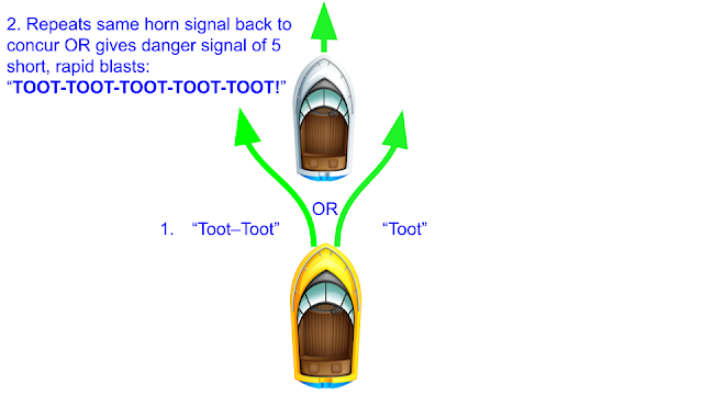
4. In a narrow, restricted channel or when there is heavy boat traffic or obstacles to negotiate, the overtaking vessel should contact the vessel that it is preparing to overtake. The overtaking vessel should propose the manner in which the maneuver is to be executed (the point at which the maneuver will take place and the side to pass on). The boat to be overtaken agrees to the proposal or requests the maneuver to happen in some other manner. The overtaking vessel should honor the request of the vessel that it is attempting to pass, unless, in the opinion of the overtaking vessel’s captain, that request would put one or both vessels in danger. In such circumstances, slowing down and remaining behind the slower boat until such time that conditions are safe to execute the overtaking is prudent. In any case, the captains of the two vessels should come to a mutual agreement about how the passage will take place. This conversation should take place on VHF channel 13, which is designated for vessel-to-vessel communications for collision avoidance. However, it seems few recreational boaters regularly monitor channel 13. If you cannot make contact with a boat on channel 13, hail them on channel 16 and request that they shift to channel 13 (channel 16 is designated for hailing and emergency communications only and all vessels that have VHF radios are obligated to monitor channel 16 at all times.) Alternatively, this entire conversation can take place very quickly and efficiently using horn signals. The overtaking vessel would initiate this conversation by requesting permission to pass by either giving one short blast (“I intend to leave you on MY port side.”) or two short blasts (“I intend to leave you on MY starboard side.”). The vessel about to be overtaken can respond in one of two ways, either by (1) agreeing to the proposed plan for passing by repeating the same horn signal back (one blast meaning “I agree to your plan for passing me on YOUR port side” or two blasts meaning “I agree to your plan for passing me on YOUR starboard side”) or by (2) communicating an objection to the proposed plan for passing by issuing the “danger signal” of 5 short, rapid blasts which in this case would mean “I disagree with your proposal for passing because it would put my vessel or your vessel in danger.” When you hear boat captains on the VHF radio talking about passing on “1 whistle” or “2 whistles,” this is what they are referring to (Inland Navigation Rule 34).
5. The overtaking vessel should pass close to the slower vessel. The overtaking vessel can maintain its speed until it is close behind the vessel to be overtaken. At that point, the overtaking vessel should swing wide to one side of the overtaken vessel (depending on the outcome of the conversation that took place in Step 4) and decelerate rapidly to no wake speed.
6. When the overtaking vessel is off the overtaken vessel’s stern quarter (and there is no longer a real danger of collision), the boat being overtaken should also slow down to make the passage go quicker and easier, without forcing the overtaking vessel to maintain a higher speed that would create a large wake.
7. As soon as the stern of the overtaking vessel passes the bow of the overtaken vessel, the slower, overtaken vessel should turn into the wake and get behind the passing boat.
8. Once the overtaken vessel is inside the wake of the passing boat, both boats can return to their cruising speeds.
9. When overtaking a barge or large vessel, never, ever cross in front of it, even if you are moving at a much faster speed than the other vessel. After overtaking a barge, continue on a course that is parallel to their course but off to the side until you are more than a quarter mile in front of it. These large vessels are not very maneuverable and they take a very long time to come to a stop. So imagine what could happen if you pulled out in front of a barge and then your engine stalled (from a fuel problem or because you ran over something like a crab pot, discarded rope or some other piece of trash that fouled your prop.)
Following these procedures, will minimize the disruption to both boats, make the maneuver go quickly and smoothly, and keep both boats safe.
Head-on Meeting
 |
| Two powerboats meeting head-on. Both must keep to the right. (Boat images from VECTEEZY.com.) |
In a meeting situation, where two power-driven vessels are approaching each other head-on from opposite directions, both vessels must give-way to the other and avoid collision by altering course to starboard so that they pass each other port-to-port (Inland Navigation Rule 14). The requirements of Rule 14 are consistent with those of Rule 9, which requires vessels to keep to the right side of the channel.
One of the most intimidating situations you are likely to encounter on the ICW is meeting a tug and barge. The most common configuration is for the tug (usually a pushboat) to be pushing the barge “on the nose.” These barges can be huge, up to nearly 300 feet long with a beam over 50 feet. Another type of large vessel that is becoming increasingly common on the ICW are coastal cruise ships. Meeting a barge or cruise ship head-on in one of the narrow cuts or canals can tie your stomach into knots. Knowing how to handle the situation and anticipating what to do is important. The following box describes the general process for meeting large commercial vessels head-on in the ICW.
 |
| A “one whistle” meeting (passing port-to-port) with a barge in the Virginia Cut Canal. |
Box
1. When meeting a large vessel in the ICW, you should consider yourself to be the give-way vessel and the larger vessel to be stand-on. Technically, under the Inland Navigation Rules, a large cruise ship or pushboat pushing a barge would not be considered a vessel “restricted in her ability to maneuver.” And there is no provision for “vessels constrained by draft” in the Inland Rules (this provision only exists in the International Rules). But as a practical matter, a tug pushing a barge on the ICW is constrained by its draft and limited in its ability to maneuver. So even though the law doesn’t give them special status, common sense indicates that you should.
2. If you have an AIS receiver, when approaching a narrow cut or canal, look at the AIS information to see whether there are any large commercial vessels that you will encounter in the canal. (Note that tugs or pushboats less than 65’ in length may not have AIS, even if they push large barges.)
3. If the AIS shows a tugboat or other large vessel in the vicinity of the canal, contact that vessel on VHF channel 13 to discuss a plan for safe passage. Often, the best thing for you to do is to wait for the large vessel to pass before you enter the narrow canal.
4. Before you enter the cut or canal, give a securité call on VHF channel 16, and continue to monitor channels 13 and 16 for responses from concerned traffic. (See below for instructions on how to make a securité call.)
5. If you are going to meet a barge or other large vessel head-on in a restricted part of the ICW, slow down and pull as far over to the right as possible (Inland Navigation Rules 9 & 14). Keep in mind that at first, the large vessel’s bow wave will push you away, toward the shore, but then after you are alongside it, you may be drawn towards it. Having the U.S. Army Corps of Engineers depth survey overlay displayed in Aqua Map makes it much easier to see how far off from the center of the channel you can safely deviate.
6. Never cross in front of a barge or other large vessel, even if you are moving much faster than that other vessel.
 |
| Meeting a 900 foot-long container ship on the Cape Fear River, NC. This ship was traveling at 14 knots over ground, against the current. Note that we are passing starboard-to-starboard. We were headed north on the ICW and had just entered the Cape Fear at South Port, NC (MM 309), which is on the west shore of the river. Rather than crossing the channel in front of the ship to get on its port side, we elected to remain on the west side of the Cape Fear River, outside of the ship channel until the ship had passed. In a meeting situation, if you can only see the bow of a ship, you are on a collision course. If you can see the side of a ship, all the way to its stern, then you know you are safe. |
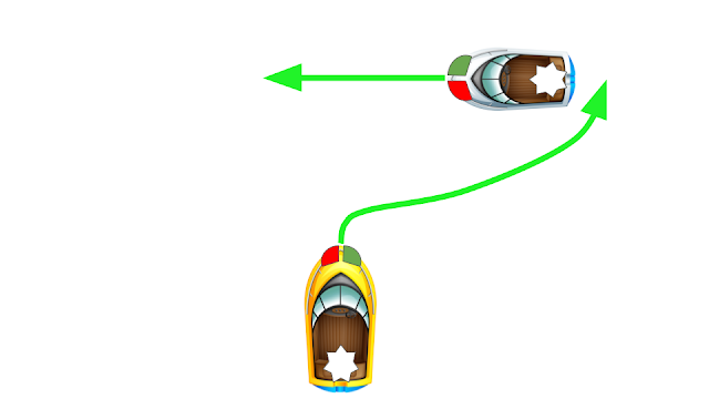
Crossing
Crossing situations, where boats are converging on different compass headings, are covered by Inland Navigation Rule 15. In a nutshell, if another boat is approaching you from your starboard side, you are required to give way and allow the other boat to cross in front of you. In this case as the giveaway vessel, your only two options are to either slow down or to change course to starboard to pass behind the other vessel. The tidal currents on the ICW may complicate this situation. A crossing situation in a strong current can have one boat headed broadside to the current and the other headed down-current. The maneuverability of both vessels will be impaired. Act early and make any change in course obvious to the captain of the other vessel.
There is one common misconception among novice boaters that is important to debunk for ICW cruisers. Just because you are traveling in a channel doesn’t mean that you have any right-of-way over boats that are cutting across that channel (unless you are in a Traffic Separation Scheme, but there aren’t any Traffic Separation Schemes on the ICW; Rule 10). Unlike highway driving, where cars that are already on the highway have right-of-way over cars that are entering or crossing, no such privilege exists for boats. First of all, there is no such thing as absolute right-of-way when it comes to boats. Second, it doesn’t matter which boat is following the channel. If you are in the ICW traveling south and another boat that is headed east is approaching on your starboard side, you must either slow down or turn to starboard to avoid collision. Those are your only two options. Similarly, boats on a heavily-traveled channel like the ICW have no privileges over boats that are crossing in a minor channel. Always be on the lookout for boats approaching from your starboard side, which is called the Danger Zone. You must give way to boats approaching on your starboard side.
 |
| Crossing situation with two powerboats. If there is a vessel approaching on your starboard side and there is any possibility that you are on a collision course, you must give way. At night, it is almost easier to remember which boat is the stand-on and which is the give-way. If you see the other boat’s red side light, you must yield. (Boat images from VECTEEZY.com.) |
Many parts of the ICW are subject to shoaling. Fortunately for boaters, the U.S. Army Corps of Engineers (and its private contractors) are working constantly to keep the waterway open. During a trip on the ICW, you are very likely to encounter dredges. There are two basic types of dredges used on the ICW: hopper dredges and cutter suction dredges. Both work like giant vacuum cleaners that suck up sediments and water. Hopper dredges look like small, ocean-going ships and are self-propelled. They are always underway when actively dredging; they maneuver into the shallow area where they suck up sediments then proceed immediately to a deepwater disposal site where they deposit the sediments. Working hopper dredges display the ball-diamond-ball vertical line of black dayshapes (and at night, red-white-red lights in a vertical line), which identifies it as a vessel restricted in its ability to maneuver, so you must keep clear of it (Inland Navigation Rule 3). Because they are often moving and maneuvering in tight quarters, it is sometimes difficult to figure out how best to stay out of their way. The best course of action is to call the dredge on VHF channel 13. Hopper dredges are most commonly used at the mouths of inlets and in deepwater ship channels.
Figure: Photo of hopper dredge
Cutter suction dredges (CSDs) are the most common type of dredge encountered on the shallower, sheltered waters of the ICW. They are barges that have a mechanical cutter head mounted on the end of a long boom that is suspended from the “bow” of the barge. The end of the boom is lowered into the water and the cutter head loosens up the sediment, which is then sucked up by a hydraulic vacuum and immediately transported through a long pipe to a shore-based disposal site. The CSD barge is moved into position by a tugboat and then held in place by anchors and/or retractable pilings, called “spuds.” In addition to the ball-diamond-ball dayshapes along its centerline (and at night, red-white-red lights in a vertical line) identifying it as a vessel restricted in its ability to maneuver, you will see two ball dayshapes (or two red lights), one directly above the other, on one side of the dredge where the pipe and other hazards are. On the opposite side, the safe side, you will see two diamonds (or two green lights) displayed (Inland Navigation Rule 3). Because there is a large pipe running from the dredge to shore, you have to be careful about which side you pass on. Always pass on the side showing the two diamonds. Remember the phrase “Diamonds are a girl’s best friend.” It’s always a good idea to contact the dredge on VHF channel 13 to confirm the safest method of passing. If the dredge operator requests that you pass it on its port or starboard, you need to know which end of the barge is the bow and which is the stern, which isn’t easy to figure out since it is a perfect rectangle and neither end is pointy. The bow of the dredge barge is the end that has the long boom that is cantilevered out over the water (the end of which will be in the water if the dredge is actively working). There is also usually a control room that overlooks the boom and faces forward. This control room looks like the bridge or wheelhouse of a ship but because the dredge barge has neither propulsion nor steering control, it is technically not a wheelhouse. When passing a CSD barge, slow down to no-wake speed. The freeboard on these dredge barges is usually quite low so a wake can wash over their deck. Nothing annoys a dredge crew more than getting waked.
Figure: Photo of a CSD dredge
The Atlantic ICW passes through many major commercial ports, including Hampton Roads/Norfolk, Beaufort Inlet/Morehead City, Cape Fear River/Wilmington, Charleston, Savannah, Brunswick, St. Johns River/Jacksonville, Port Everglades/Ft. Lauderdale, and Government Cut/Miami. In these locations, and a few others, you are likely to encounter large ships such as cruise ships, container ships, car carriers, bulk freighters, and military vessels. Ships move faster than they first appear. From a distance, they look to be slow and lumbering. As the ship gets close, you may be shocked at how fast it is actually moving. On the open ocean, many of these vessels travel at speeds well in excess of 20 knots. But even in the wider sections of river channels, we have seen large ships making 18 knots. If your course is converging with that of a ship, you have less time to react than it initially appears. The best way to avoid these ships is to stay out of their way, outside of the main channel. Commercial ship channels are generally 35’ deep or more and are marked by very large navigation buoys. Private yachts can usually navigate safely on the outer edge of the channel or just outside the buoys, where the water is sufficiently deep but where the large ships won’t approach. Just be sure to consult a chart first before assuming there is enough water to stray outside the marked channel, and watch your depth sounder. Keep to the right-hand side of the channel. If you have to cross the ship channel, do so as quickly as possible, which usually means crossing the channel at a right angle. And monitor both VHF channels 16 AND 13. Channel 13 is specifically used for vessel-to-vessel communications to arrange passing maneuvers and avoid collisions. Large vessels are required to monitor channel 13 (as well as 16) while in harbors or on inland waters. You will probably have more luck contacting ships and tugboats on channel 13 than on 16.
Making a Securité Call
Making a securité call (pronounced “securitay”) on your VHF radio is what you do when you need to broadcast a message about navigational safety to all nearby vessels. You may be transiting a heavily trafficked channel in thick fog or approaching a narrow channel that isn’t wide enough for two-way traffic. A securité call is simply a way of announcing your presence to any other vessel that you may encounter in the narrow channel. It can also be used to report hazards to navigation, such as a log floating in the channel. A securité call consists of 5 parts: (1) Identifying the call as a securité call, (2) identifying your vessel, (3) describing your location and the safety concern, (4) notifying other vessels how they can contact you if they have any concerns or need additional information, and (5) a sign off, which is like the period at the end of a sentence and lets everyone else know that you are done with your message.
Figure: photo of radio and of someone making a radio call.
Box
Make sure that your radio is tuned to Channel 16. Before making your call, listen for at least 20 seconds to make sure you won’t be interrupting a conversation that is already in progress. (You should be monitoring channels 13 and 16 at all times). Press the microphone key before you start speaking, and speak clearly. Say the 5 following things as one, continuous statement.
1. “Securité, Securité, Securité.”
2. “This is the sailing/motor vessel ________, ________, ________…” (name of boat three times)
3. Describe your location and your safety concern. This is the part that will vary. Here are some examples:
a.“...headed southbound, passing ICW Marker 15, and about to enter the north end of the Rock Pile.”
b. “...headed northbound, passing ICW Marker 20, and about to enter Elliott Cut”
c. “There is a partially submerged log adrift in the channel near ICW Marker #91 in the Waccamaw River, about ¾ of a mile north of the U.S. Highway 17 bridge.”
4. “This is the sailing/motor vessel ______, standing by on Channels 13 and 16 for any concerned traffic.
5. “Sailing/motor vessel _____, out.”
Continue monitoring channels 13 and 16 in case other vessels need to contact you about this safety concern.
Steps 1, 2, 4, and 5 will always be the same. So practice saying them. Number 3 is always different but it contains the most important information. Always make sure you say where you are and if the concern has to do with a hazard to navigation, make sure you describe it clearly and concisely.
On the ICW you don’t necessarily need to give a latitude and longitude because there are plenty of place names, landmarks, and numbered channel markers that can convey your precise location more easily than can a string of numbers. However, if you are on a sound or on the ocean, you should provide the latitude and longitude as well as a distance and direction from a well-known feature such as a buoy, inlet, or point of land. For example, you might say something like this if you run across a navigational hazard in the ocean, off of Beaufort Inlet:
“There is a partially submerged shipping container adrift at position 34 degrees 36.7 minutes north, 76 degrees 44.2 minutes west, or approximately 2.5 nautical miles west of Beaufort Inlet buoy #1. Repeat 34 degrees 36.7 minutes north, 76 degrees 44.2 minutes west, or approximately 2.5 nautical miles west of Beaufort Inlet buoy #1.”
When you make a securité call to let other boats know about a navigational hazard, you should also contact the local U.S. Coast Guard station directly to inform them of the hazard (on VHF channel 16 or by phone). If necessary, the USCG can make periodic securité calls and arrange to have the navigational hazard removed.
Maintaining Maneuverability and Avoiding Allision
Allision is when a boat runs into a stationary object, such as a channel marker or moored vessel, which differs from a collision involving two vessels that are both underway. A surprising number of boats run into stationary objects. Usually the cause of these allisions is a combination of inattention, the effects of the current on a boat’s speed and maneuverability, and using autopilot in congested waters. In many of the allision cases with which we are familiar, the boat had a following- or cross-current and the operator either failed to recognize this current or failed to understand how it could limit their boat’s ability to maneuver. So let’s get a better understanding of how currents can affect your boat’s maneuverability and how to avoid obstacles, given these limits to maneuverability.
Many stretches of the ICW have swift currents. The strongest of these currents are generated by the combination of tides interacting with the shoreline and the outflow from rivers. Tidal currents can be considerable, even in regions that do not have particularly large tidal ranges.
The speeds of tidal currents are generally slower the further away you move from an inlet. That is, the further upstream you go in a river or the closer you get to the tidal convergence zone on the back side of a barrier island, the slower the tidal current will be. Swift tidal currents generally make maneuvering in and around the inlets more challenging than further inside the estuary. Additionally, when the wind opposes the tidal current in an inlet, you can have some unpleasant sea conditions: large, steep, breaking waves that are packed together closely.
When thinking about the effect of currents, we need to make a clear distinction between the two ways in which we measure a boat’s speed, which are speed through the water (STW) and speed over ground (SOG). STW is the speed of your boat relative to the water immediately surrounding it. SOG is your speed relative to fixed objects, such as channel markers, docks, or the seafloor itself (i.e., the “ground”); it integrates the boat’s speed through the water and the motion of the water itself. To illustrate, if your boat motors at a speed of 5 knots on still water, both your STW and SOG are 5 knots. However, if you then keep the engine RPMs constant and head into a 1-knot current, your STW remains 5 knots while your SOG would drop to 4 knots. If you then reverse course and head with the current, your STW will still be 5 knots but your SOG will increase to 6 knots. SOG is typically the measure of speed given by your GPS and it’s what matters when you are trying to predict your time of arrival at a destination. STW is the measure given by paddlewheel or acoustic speed sensors.
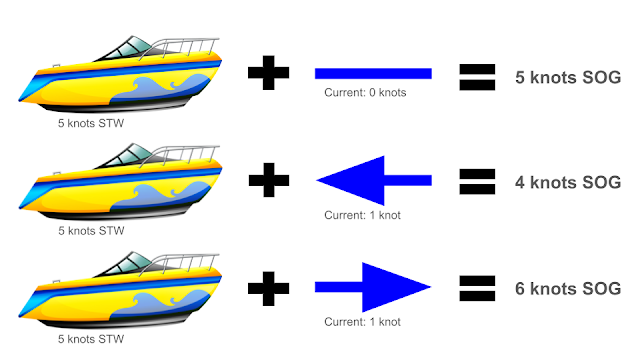
The speed and direction of the current plus a boat’s speed through the water (STW) determine its speed over ground (SOG).
(Boat images from VECTEEZY.com.)
How does this matter to you as you’re cruising down the ICW? When it comes to running aground or alliding with a fixed object, the difference between SOG and STW is very important. STW determines your boat’s maneuverability; your rudder can only turn the boat when water is flowing past it. You must maintain a minimum STW to maintain steerage. SOG is what determines how hard the impact will be when you hit a fixed object. Therefore, when your SOG exceeds your STW (i.e., you are traveling with the current), it is easy to underestimate the force of a potential impact with an object and to overestimate your ability to maneuver in close quarters. This is why we always try to approach a dock, mooring, or other fixed object from its downstream side (i.e., we approach it by heading up into the current). Doing so maximizes your STW (maximizing your maneuverability) and minimizes your SOG (minimizing the risk of serious damage if you hit something).
Sailboats are designed to maintain steerage at very low STW, down to about half of a knot. They’re able to do this because they have very large rudders. The rudders on powerboats are much smaller in comparison. Therefore powerboat rudders are less effective at slow speed. In fact, most powerboat rudders are ineffective when the boat is coasting in neutral, even if it is still moving at a few knots, STW. The engine has to be in gear with prop wash flowing past the rudder to turn the boat. Powerboats make up for their small rudders with much higher thrust and, in many cases, by having twin engines that can pivot the boat in very tight quarters. So in close quarters, powerboats generally rely less on STW to maneuver than do sailboats. Of course, if your boat has a bow (and/or stern) thruster, everything is easier.
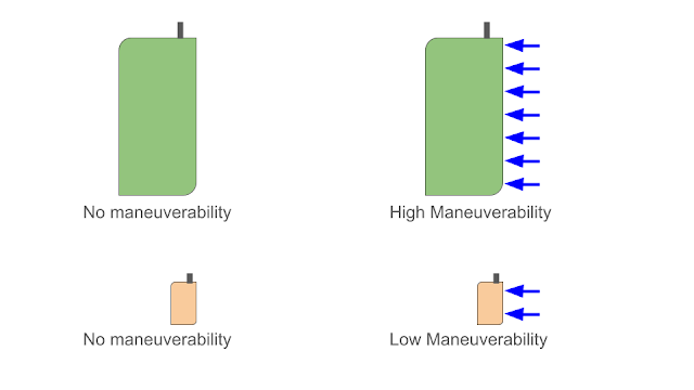 |
| Sailboat rudder (top) versus a typical powerboat rudder (bottom). On the left, the boat’s STW is 0 knots. In the images on the right, the arrows indicate the flow of water over the blade of the rudder. The larger surface area of a typical sailboat rudder can create more turning force than can a typical powerboat rudder while moving through the water at the same speed. |
Box
Keep Current on the CurrentAs you travel down the ICW, the direction and speed of the current will change constantly. Not only does this affect your speed over ground but a cross-current can also push you out of the channel, affect how your boat maneuvers, and make it surprisingly difficult to avoid obstacles. For this reason, you have to pay constant attention to what the current is doing. As you pass fixed objects such as crab pot buoys, channel markers, and pilings, get into the habit of looking at how the water is moving past them. In what direction is it flowing and generally how fast is it going? Is there a big wake, a small wake, or no wake at all? Are the crab pots and nav buoys being dragged underwater or are they standing up straight? Which way is the “V” of the wake pointing? Is the current going to set you off to the side of the channel? With a little bit of practice, you will be able to gauge the current from the wake that these fixed objects create. This will then let you know how much you need to compensate with your steering to stay on your line and how far ahead you need to anticipate any needed course changes to avoid obstacles.
Bucking into a current can be maddeningly frustrating. Your speed over ground is low and small adjustments to the helm result in large lateral changes to your heading, further slowing your progress. Overcompensating in one direction and then the other makes your boat fishtail from side to side. Make slow, steady changes and anticipate how the boat will react. Inattention is inefficient; it will cost you time and fuel.
Going against the flow can be difficult; going with it can be worse. When going with the current, turning the helm makes it look like you have changed your heading significantly because the bow turns, but you may still be going in more or less the same direction, being carried sideways by the current. When going down-current, you need to anticipate and make course changes sooner than you would on still water. In addition to making course changes earlier, you may also need to make larger course changes than you normally would on still water. In addition to those modifications, you may need to increase engine speed to maintain your rudder’s ability to steer your vessel. If you have a choice, pass fixed objects, such as channel markers, on their down-current side (on the side that is downstream of the object) and give them plenty of room. If you have to pass a fixed object on its upstream side, or if you have to curve around a mark on its upstream side, give yourself at least a couple boat lengths of space before turning across the current upstream of the obstacle. The more room, the better. If you cut it too close, the current can push you into the object. When you turn your boat broadside to a strong current, you have lost much of your ability to control the boat’s speed and direction; the current is carrying you along.
Insert Figure showing how to pass a fixed object in a current
Many novice boaters, when navigating down a channel, tend to focus on their chart plotter. Chart plotters and electronic charts have made navigating much easier. But don’t forget to look out at the real world and see what’s actually going on around you. You need to look out at the water because there are objects out there that don’t appear on your instruments: small boats, kayaks, jet skis, floating logs, crab pots, etc. You also need to look at the water itself to see how it is moving and how it is affecting your boat. To make it easier to keep your focus out on the water while remaining within the channel, steer toward landmarks. As you exit a turn, pick out a fixed landmark to steer toward that looks like it is in the direction you need to go: a channel marker, radio tower, a house, a tree, or anything you can pick out. After you have been steering toward that landmark for several seconds, glance at your plotter and see if you are on the right track. If you need to adjust your heading, choose another landmark. Keep steering toward it and check the plotter again, then make finer and finer adjustments to your heading (choose a new landmark) that keeps you safely in the channel. Another reason not to focus so much on your chart plotter (or tablet computer, laptop, or phone) is that there can be a time lag between the movement of your boat and what your electronics are displaying. If you steer by looking primarily at your chart plotter (or tablet or phone), you may find that you are continually oversteering in one direction and then the other. You can go mad steering by your chart plotter, especially when going down-current.
There are some sections of the AICW where the tidal current absolutely roars (e.g., Elliott Cut, just south of Charleston) and if you are in a relatively slow boat, you will probably need to time your passage to coincide with the tide. But, on most days, you'll just get underway in the morning and take whatever comes. This means you'll probably spend more time bucking into a current than you will riding along with it. But the distances you cover in each situation will be about the same. This can be difficult to handle, psychologically. Enjoy the fast speeds achieved during fair tides, but know that it won’t last long. And when you are slowly bucking into the current, know that you will make up some time when the tide turns (or when you pass the next inlet or tidal convergence zone).
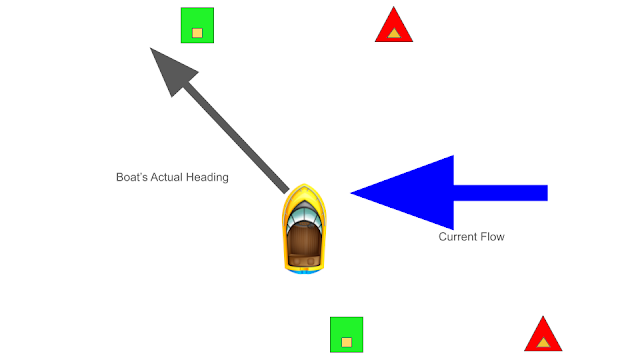 |
| A boat “crabbing” sideways because of a cross-current. The bow of the boat is pointed toward the center of the channel, between the next set of red and green markers. But the actual direction of travel differs significantly from the direction in which the bow is pointed. This can go unnoticed for quite a while. By glancing back at the markers that you have just passed, you can easily recognize that you are being swept out of the channel. |
Out on the water, we use a lot of sensory cues, besides our navigation instruments, to help us assess our boat speed and direction of travel. We look at the bow wave and wake that our boat is creating, and listen to the speed of our engine or to the “hiss” of the water going by when we’re sailing. You may not even realize that you’re doing it, but you probably are. And this information is coming in constantly. But it only gives you information on STW. Then every once in a while you pass close to a fixed object such as a channel marker or crab pot buoy and this gives you visual information on the water’s movement and your speed over ground. Sometimes when this happens you say to yourself “Holy $#%+!, I’m moving much faster than I thought.” Now, you’re probably thinking that your GPS indicates your SOG. This is true. But remember that the current isn’t always flowing from directly behind or directly ahead. Often, it’s flowing across your path, pushing you sideways. Just because your bow is pointed in a particular direction doesn’t mean that’s the actual direction in which you are moving. The degree to which your boat is slipping sideways is more difficult to detect by just looking at your instruments (although displaying a heading line on your plotter is helpful). That’s why it's so important to constantly monitor the speed and direction of the current by looking at how the water is moving past fixed objects such as pilings and buoys. Stay current on the current! This is one of the ways in which crab pots are actually helpful. If you find that you are having to dodge and weave through dozens of crab pots, then you’re probably not where you’re supposed to be. With some exceptions (such as Albemarle Sound), crabbers usually avoid setting their gear in the middle of the channel. It costs them money when their pots get destroyed or dragged away by boats, so they tend to avoid putting gear where there is a lot of boat traffic. Also, during the warm months in a lot of places (e.g., Pamlico Sound and the Pamlico & Neuse Rivers), blue crabs tend not to be found in the deeper channels; they’re in shallower water, usually from the shore to a depth of about six feet. You may also notice that the pots are usually set in straight lines, with the buoys spaced out by about 100 to 400 feet. If you recognize the linear patterns in which the pots are set, they are easier to avoid. Where you're most likely to have a problem with crab pots is when you pull off of the ICW to find an anchorage for the evening. If you do have to pass close to a crab pot buoy, try to do so on its leeward or down-current side. Doing so means that the rope attaching the buoy on the surface to the trap on the seafloor will be angling away from your keel. Crab pot buoys tend to be a lot more difficult to see than are lobster pot buoys in New England. Pots set for blue crab use smaller buoys that are often unpainted and coated with algae, making them blend in with the green/brown water.
Insert a figure showing what a crab pot & buoy looks like in a current.
Night Life
Most of us try to avoid navigating the ICW at night. But sometimes you can’t avoid it, especially during the short days of late fall and winter. Maybe you have a 4-legged crew member who needs a nightly dinghy ride to shore. We love to be out on the water at night. But we carefully choose the places where we go, and try to check them out in the daylight first before going there at night. The two biggest concerns with boating at night are that (1) it is much more difficult to judge distances to objects at night, and (2) you can’t see the water to tell which way or how fast the current is moving. Having a good, powerful spotlight helps with both of these problems. Estimating the distance to lights, such as a lighted channel marker or boats displaying running lights, can be really difficult. The higher the light is above the water, the further off on the horizon it appears to be. Tall daymarks (the channel markers that consist of green squares and red triangles mounted on pilings) at low tide have a way of sneaking up on you; you think it’s far away and then all of a sudden it’s right in front of you. The best thing to do is to shine a spotlight on that channel marker, even when it may seem too far away to be reached by the spotlight’s beam. Being able to see the reflective numbers and the waterline on the piling makes it immediately clear how far off in the distance it really is. We can’t tell you how many times we’ve looked at a light on a channel marker thinking it was half a mile or more away, only to realize that it was less than 100 yards away when we shined a light on it. Shining that spotlight on the waterline of the fixed objects that you pass will also help you see how the water is moving. Never point a spotlight at another vessel. You don’t want to blind the pilot of the other boat. If you are concerned that another boat doesn’t see you, shine your spotlight on your boat, to make it more visible. Make sure your boat is displaying the proper navigation lights for your vessel’s type and its current activity (e.g., motoring, sailing, at anchor) (Inland Navigation Rules 20-31). Remember that your navigation lights are not simply to make your boat visible. Your lights need to communicate specific information to other boats, including:
the type of vessel that you are (e.g., motor, sailing, or fishing vessel),
what you are doing (e.g., underway versus at anchor),
how large your vessel is, and
the direction in which you are heading.
The legally required navigation lights communicate all of this information. Hanging a bunch of Christmas lights or patio lights on your boat may make it more visible but they don’t communicate any of the above information and they don’t fulfill the legal requirements. To the extent that they obscure your navigation lights, extra lights can actually increase the danger in some circumstances. While anchored at night, it can be a good idea to light your boat up, as long as your legal anchor light is well above all the other lights and isn’t obscured. Your decorative lights should not easily be confused with lighting prescribed by The Rules. For example, avoid using extra red or green lights.
 |
| A clump of dead marsh grass on Duplin River, Georgia. Sometimes these "rafts" can be quite large, capable of fouling a prop. |
BoxStopped Dead in our TracksMany years ago, we cruised the west coast of Florida. One day, we were on the GICW, in Venice, when all of a sudden, the entire boat shuddered and vibrated violently, and then the engine stalled. Fortunately, we were able to set the anchor before going aground. We immediately suspected that something had fouled our prop, requiring someone to go for a swim. This sounds easy enough, as it was late May in South Florida and the water was over 80 degrees, except that this section of the ICW is truly a narrow ditch cut through the land and the shore is lined by granite riprap. Power boats were zooming by us on both sides. Did we mention that it was Memorial Day weekend? Oh yeah, and we were right next to the city’s sewage treatment plant. At this point we were second-guessing a lot of our life choices. But we made a securité call on channel 16, and Damon put on a dive mask and jumped over the side. A heavy, clear plastic bag was wrapped around the prop. Spurred by his desire to get the heck out of that water, it only took a minute or two to clear the prop, and then we were back in business. This incident shows that it doesn’t take much to foul your prop and stop you dead in the water. Avoiding such floating hazards is far easier than removing them from your prop. A clear plastic bag is hard to see in the water, but there are lots of more visible hazards drifting around.
Finally, a Note about Wakes
“Don’t tow a big wake.” This should be a guiding philosophy of life as well as a basic principle of inland boating. There are four things that you need to keep in mind about your wake:
1. You are responsible for your wake, whether or not you’re in a No Wake Zone. If your wake causes injuries or damage to waterfront property or to other boats, you can be held liable in civil or criminal court.
2. The wake from a boat with a planing or semi-displacement hull actually gets larger when the boat slows from planing speed to plowing speed. If you’re going to slow down to reduce your wake, you have to slow WAY down. The best thing to do is to slow all the way down to idle speed. Once the boat settles back into the water, you may be able to increase speed again by a small amount without making a large wake. If you don’t slow down enough, you will continue to drag the wake behind you. Therefore, if you’re not going to slow down enough to actually reduce the size of your wake, you might as well just keep going at planing speed.
3. Your wake travels forward. If you are going to slow down to reduce your wake for an oncoming vessel, a small boat tied to a dock, or for a no wake zone, you need to slow down well ahead of the point at which you will meet the other boat or “no wake” sign. Remember, when you slow down, your wake will get larger before it gets smaller.
4. The wake from an overtaking vessel causes more problems than does the wake from a boat headed in the opposite direction. Getting hit by a wake from the stern quarter makes a boat roll violently (especially a sailboat). See the box describing the procedure for overtaking and being overtaken for ways to minimize impacts on both vessels.
 |
| A wake on Doboy Sound, GA. If you've never been to Georgia, you might look at this photo and think that the boat is scraping bottom and churning up mud. But this is actually what the water in Georgia looks like. There are a lot of plant pigments dissolved in the water, coloring it a greenish brown, and it carries a lot of suspended sediment. The color and turbidity of the water make it difficult to see the shallow spots. The good news is that the bottom is mostly soft mud. |
Conclusion
In the heat of the moment, if you can’t recall the specific navigation rules that apply or you can’t remember the advice given here, just try to exercise common sense, courtesy, and caution. If you do that, you’ll probably be in compliance with the Rules and you’ll stay safe.
To Learn More
USCG’s Office of Navigation Systems - Navigation Rules and Regulations Handbook 2020 (This is what you need to have aboard your boat. It is formatted to show the International and Inland Rules side-by-side. If you are staying on the inland waters, you can just read the Inland Rules portion of this publication. You can order a hard copy here.)
NOAA’s Amalgamated Publication of the International and U.S. Inland Navigation Rules (This contains the same information as the publication above and also satisfies the “copy of the rules” requirement. But instead of displaying the International and U.S. Inland Rules side-by-side, both in their entirety, it amalgamates the two sets of rules and then highlights the differences between them. So this document is significantly streamlined compared to the one above. You can order a hard copy here.)
Amalgamated International and Inland Navigation Rules web site (website that makes it easy to navigate the Navigation Rules)
- Introduction
- Chapter 1: Tips & Tricks
- Chapter 2: Water Levels
- Chapter 3: Avoiding Obstacles
- Chapter 4: Running Aground
- Chapter 5: Bridges
- Chapter 6: Inlets
- Chapter 7: Docking, Anchoring & Mooring
- Chapter 8: Navigation Electronics
- Chapter 9: Weather Basics
- Chapter 10: Typical Weather
- Chapter 11: Environmental Stewardship
- Chapter 12: The Perfect Boat
- Chapter 13: Maintenance
- Chapter 14: Conclusion
- About the Authors
