Chapter 5: Bridges
 |
| Fixed bridges (State Road 312 bridges in St. Augustine, MM 780). From a distance, it can be difficult to tell where the channel passes under a fixed bridge. Look for the bridge fenders that line either side of the navigation channel (those large wooden structures protect the bridge supports from being struck by vessels) and the three light fixtures that are below the roadway. One light marks the center of the channel (green light at night) and two mark the outer edges of the channel, one on either side (red lights at night). |
Surviving Thriving on the ICW
5. Avoiding Mishaps at Bridges
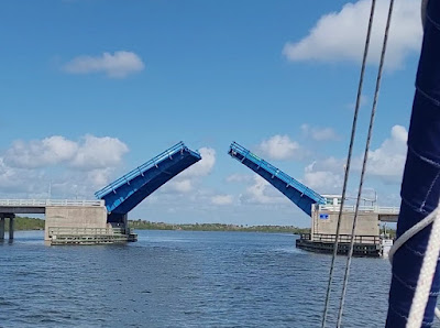 |
| L.B. Knox Bridge, just north of Daytona, FL (MM 816). This is a bascule bridge (AKA, drawbridge). Most opening bridges open on a schedule. Opening times, clearances, and contact information for the bridge tender can be found using the Waterway Guide Explorer. |
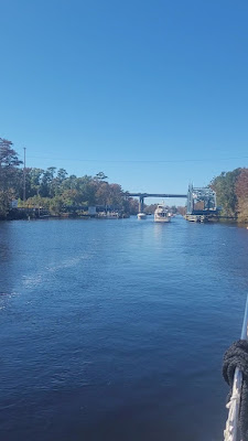 |
| The Socastee Swing Bridge (foreground) and the Benjamin Thrailkill Fixed Bridge (background) (MM 371). The swing bridge is open for boat traffic. This particular swing bridge has just one lane for boat traffic. Some swing bridges pivot in the center, allowing for two-way boat traffic in separate lanes, along either side of the opened bridge. |
Some opening bridges are high enough, even when closed, for a lot of power boats to fit through. However, many cruising boats require opening bridges to be open. Note that if you are able to fit under an opening bridge that is closed by lowering antennas or other moveable appendages atop your boat, then you are required to do so. Bridges only open for vessels that absolutely cannot fit otherwise. Some bridges open on request but most open on a schedule. Regardless of whether a bridge opens on request or on a fixed schedule, when you arrive at an opening bridge, you should contact the bridge tender by VHF radio. Most opening bridges in Florida monitor channel 9; elsewhere, most bridges monitor channel 13. (Check the Waterway Guide Explorer for information on the opening schedule and contact information for each bridge.) Many bridge tenders will ask for your vessel's name and either the registration number (for state-registered vessels) or documentation number (for federally documented vessels). Have those numbers handy, near your radio. Also, if your boat's name is unusual or complex, you will probably have to spell it out for most bridge tenders. For clarity, use the phonetic alphabet for spelling words over the radio. We keep a notebook at the helm for important navigation information, such as bridge locations, clearances, opening schedules, and contact information. On the front cover of the notebook, we have our documentation number and the phonetic spelling of our vessel's name (Fulmar: Foxtrot - Uniform - Lima - Mike - Alpha - Romeo).
If you arrive early for a scheduled bridge opening, you will need to wait. If you are headed downbound (i.e., traveling with the current), stop and wait well short of the bridge to avoid getting pushed into it by the current. If you are heading into the current, then you can get closer to the bridge before stopping because it is easier to maintain steerage at a very low SOG when heading into the current.
Most opening bridges (and some fixed bridges) are only wide enough for one-way vessel traffic. In this situation, a good rule of thumb is to allow the downbound vessels to transit the bridge first because they would have more difficulty maintaining station with the current pushing them from behind, and because they’ll be able to pass through the bridge quicker since they are going with the current. This is not a formal navigation rule on the ICW; it’s just good practice (this is a requirement on the Great Lakes and Western Rivers, but not on other water bodies). The problem is that not many recreational boaters know about this convention. If there are boats waiting on both sides of the bridge, it is good to contact the other vessels on VHF 13 or 16 to work out an agreement about who should go first. Unfortunately, again, a lot of recreational boats don’t have or don’t use a VHF radio, so be on the lookout for some boats to do unexpected things. Don’t expect the bridge tender to play the role of traffic cop (but they can tell you if the span is wide enough for two-way traffic, if both sides of a swing bridge are open to traffic, and if there are any vessels approaching from the opposite direction).
Proceed through in a single file as quickly and safely as possible, without throwing a large wake. Don’t slow down until you are well past the bridge. Let all of the traffic waiting on one side to clear out before any boats on the opposite side begin to move through. Remember to keep to the right, especially if you're waiting for oncoming traffic to transit first. And don’t crowd the bridge opening; stay clear of the bridge fenders until it’s your turn to go through. The order of which boat goes first is usually determined by who arrives at the bridge first. But if you arrive early at the bridge and a boat that is obviously faster than you arrives after you, while you are still waiting for the opening, it is often a good idea to let the faster boat go ahead of you. If they’re going to pass you anyhow, you might as well let them do it when they are moving slowly and not throwing a wake.
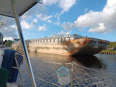 |
A “pushboat” tug with a barge “on the nose” at Great Bridge, VA (MM 11.5). The barge just cleared the lock and is heading south, waiting for the drawbridge to open. Do whatever you can to stay out of the way of large, commercial vessels. (In this photo, our boat was tied to the dock as the barge passed.) |
Currents are magnified where the waterway narrows down to a pinch point, which is the case at many bridges. Expect the current to be gnarly around the bridges. Both fixed and opening bridges have fenders that protect the bridge foundations or pilings. These bridge fenders act like funnels. Be aware that if you are approaching a bridge with current pushing you from behind, the current will force you toward the fender, especially if the bridge is located where the channel curves, which is pretty common. Then as you get under the bridge, the current will often suddenly push the boat toward the center of the channel, and possibly toward oncoming vessels. In such close quarters, you have to anticipate these effects of the current and react quickly to compensate for them.
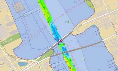 |
| Sea Breeze Bridges in Daytona, FL (MM 829). The causeways that connect the bridges to the land form a pinch point in the waterway, which causes the current to accelerate. This image is from the Waterway Guide Explorer. Clicking on that bridge icon opens a page of information on the bridges. |
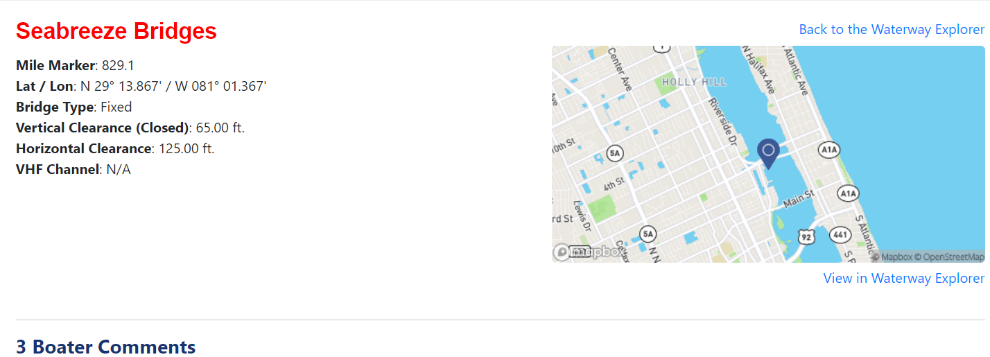 |
| This is the information on the Seabreeze Bridges, given by the Waterway Guide Explorer. For opening bridges, it also provides the schedule of openings and the VHF channel that should be used to contact the bridge tender (usually 9 or 13). |
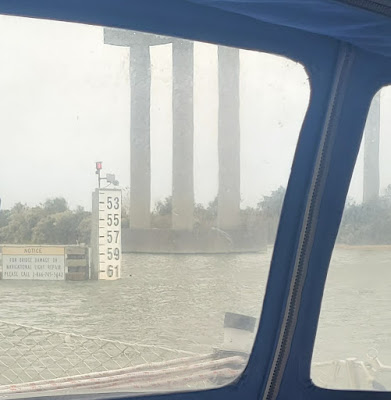 |
| It’s pretty common to have less than 65 feet of clearance at fixed bridges. This is the Isles of Palms Connector Bridge (MM 459) near high tide, after a couple days of northeasterly wind pushing ocean water into the estuary. |
The fixed bridges on the AICW are called highrise bridges and, with one exception, are supposed to have a minimum clearance of 65 feet at mean higher high tide. (The exception is the Julia Tuttle Bridge in Miami at MM 1087, which has a clearance of 56 feet.) So why, then, do we hear so many anecdotes from cruisers describing bridge clearances of less than 65 feet? There are four reasons for this, which were all described in Chapter 2 (tides, wind, rainfall, and relative sea level rise). That magic 65 foot clearance is expressed relative to mean higher high water (MHHW). So, first of all, what is mean higher high water? Well, every day there are two high tides. These two high tides are unequal in height. MHHW is simply the average height of the water during the higher of each day’s high tides. Since the value is an average, some high tides are going to be above average, during which there will be less than 65 feet of bridge clearance. So even in the absence of the other three factors, there would still be times when there would be less than 65 feet of clearance. But this would be quite rare without the other three factors that affect water level. Add in the effects of wind, rainfall (especially at the Socastee Highway Bridge), and relative sea level rise (most relevant for bridges built prior to 2000), and you will find that some of these bridges can frequently have less than 65 feet of clearance.
Most of the bridges on the ICW were built to a standard sea level benchmark set in the 1980s. However, relative sea level has been rising, and the rate of sea level rise appears to be accelerating. For the past 15 years, relative sea level (i.e., the combined effects of a rising sea level and sinking land) has been rising at a rate of almost half an inch per year along much of the Southeast U.S. This means that sea level today is higher than it was when the sea level benchmark was set in the 1980s. State departments of transportation are using new, higher benchmarks for sea level for the purposes of new bridge construction, but older bridges are stuck at the old bench mark. Since bridges have a life expectancy of over 50 years, the clearance under them can become significantly reduced over time.
The truth is that the vertical clearance at MHHW is now less than 65 feet at many fixed bridges. As discussed in Chapter 2, the problem of low bridge clearance tends to be greatest where the tidal range is lowest (i.e., inland areas of Virginia, North Carolina, and South Carolina). At some of the bridges in these areas (particularly the older ones), there can be long periods during which the clearance is less than 65 feet. And the proportion of time during which the clearances are less than 65 feet is increasing because of relative sea level rise. Are there periods of time when these bridges do have 65 feet of clearance? Yes, absolutely. But the proportion of time during which there is at least 65 feet of clearance is decreasing. In areas with large tidal fluctuations, like southern South Carolina and Georgia, simply waiting a few hours after a high tide will give you a couple more feet of clearance.
Striking a bridge with the top of your mast could be catastrophic. Your mast is not designed to absorb an impact, especially not near its top. It can take a surprisingly small amount of force at the top of the mast to cause the entire rig to come crashing down (especially on monohull sailboats). This could be life-threatening for anyone aboard the boat. We cringe when we see people nonchalantly pinging their VHF antenna along the bottom of a bridge span or joking about having just a couple of inches to spare. Combine this careless attitude with a strong, following current that can pin you up against the bridge, making it difficult or impossible to extricate yourself, and you could have a very bad situation; not just a situation that results in damage to your boat, but one in which people can be seriously hurt.
The bottom line is that if your air draft is greater than 62 feet, you need to pay close attention to bridge clearances. You need to know the exact height above the water of the highest instrument atop your mast. Then add in a little margin for safety. If you are close to 62 feet, you should do the actual measurement yourself, on your boat, rather than rely on the builder’s specs. With your rig’s height in mind, look ahead to the tide boards indicating the actual clearance under a bridge at the present time. (“Tide board” is a misleading name since they indicate the clearance under the bridge, regardless of the forces driving changes in water level.) The clearances shown on the tide boards are measured to “low steel,” the lowest portion of the bridge structure that is above the channel. Many bridges are arched so there may be greater clearance under the center of the arch, which may or may not be over the channel. If it looks like it is going to be close, don’t take chances. There are also tide gauges and river gages that you can monitor online to get water level information before you arrive at the bridge. (Don’t ask me why river “gage” is spelled without a u; it just is.)
 |
| A motor vessel transiting through the Great Bridge Bridge in Chesapeake, VA (MM 11.5). Yes, you read that correctly. It's called the Great Bridge Bridge, to distinguish it from the Great Bridge Lock. Confused? Don't worry, you'll understand when you get there. |
Conclusion
To Learn More
Tools
- Waterway Guide Explorer (The chart viewer has bridge information, including clearances at MHHW, opening schedules, and comments from boaters)
- National Water Prediction Service (Water Levels)
Contents
- Introduction
- Chapter 1: Tips & Tricks
- Chapter 2: Water Levels
- Chapter 3: Avoiding Obstacles
- Chapter 4: Running Aground
- Chapter 5: Bridges
- Chapter 6: Inlets
- Chapter 7: Docking, Anchoring & Mooring
- Chapter 8: Navigation Electronics
- Chapter 9: Weather Basics
- Chapter 10: Typical Weather
- Chapter 11: Environmental Stewardship
- Chapter 12: The Perfect Boat
- Chapter 13: Maintenance
- Chapter 14: Conclusion
- About the Authors
