Chapter 6: Inlets
 |
| The mouths of inlets are notorious for their large, breaking waves (photo: NOAA) |
Surviving Thriving on the ICW
6. Inlets - The ICW Cruiser's Gateway to the Ocean
Many cruisers alternate between taking the ICW and bouncing offshore. There are lots of reasons one may want to head offshore. You can make miles faster, travel day and night, get away from the vessel traffic and obstacles, and sailboats can shut off their engines and actually sail. A lot of cruisers prefer to travel offshore and only come into the ICW when the forecast calls for rough weather. Some boats need to bypass certain sections of the ICW to avoid shallow water or low bridges. We love sailing in the ocean and understand the attraction. However, when you head offshore, you have to understand the potential risks. Venturing far from shore is not usually the issue; the real risks occur when you are in near-shore waters, returning from the ocean. If you are going to move back and forth between the ICW and the ocean, remember one thing: The single most dangerous thing most cruisers do in their boats is enter an inlet from the ocean. Transiting an inlet is serious business, which should never be taken lightly.
Figure: Photo of a rough inlet
As we sit down to write this, news is just coming in about another sailing yacht that ran aground and subsequently sank while trying to seek shelter by entering an inlet. This time it was Ocracoke Inlet, scene of many similar incidents. We can understand a sailor’s desire to get to the nearest inlet when they are offshore and the weather turns nasty. But that is usually the worst decision you could make. (Well, maybe the second worst decision; the worst being to go offshore when the weather was predicted to be rough in the first place.) Being offshore in a storm is uncomfortable for the crew but the boat can usually handle it. Attempting to come into an inlet when sea conditions are rough is how boats founder and their crews get killed. In this recent case in Ocracoke Inlet, the crew was lucky to have survived the ordeal. In March of 2024, the two crewmembers of a local sportfishing boat that apparently capsized in Oregon Inlet were not so lucky.
It’s one thing to go offshore because that’s where you want to be. In that case, pick your weather window, pick your inlets, go out, have a great passage, and enjoy that clear, blue water. But if you’re going offshore just to avoid a shallow spot in the ICW, you should realize that you may be trading a minor inconvenience for a potentially serious danger. It’s like refusing to wear a seatbelt because you once heard a story about a person who survived a fiery car crash because they were unbelted and were thrown free from the wreck. The story may or may not be true. But, statistically speaking, you are much safer in a car if you are wearing that seatbelt. Likewise, you are safer staying in the ICW. Even if you run aground in the ICW, you’re not going to risk your life and you probably won’t do serious damage to your boat (as long as you don’t run aground at high speed). If your goal is to head offshore to increase the number of miles that you can cover in a certain amount of time, here are a few things to keep in mind. Along the East Coast of Florida, the distances between inlets are practically identical, whether you go offshore or take the ICW. Of course, the offshore route bypasses bridges, no wake zones, and A LOT of boat traffic on the ICW in South Florida. In South Carolina and Georgia, even though the ICW meanders, taking the offshore route is generally longer, unless you make long jumps. If your plan is to day-hop offshore, you'll end up having to travel much further because of the distance from an anchorage to open water on the ocean before you can turn north or south. Then at the end of the day, you’d have to head back in another inlet and reverse the process. That's a lot of miles just heading inshore and offshore, without making any progress toward your destination. Also, to do short day hops, you would have to use some inlets that you’d be better off avoiding. Furthermore, getting from southern North Carolina to Virginia in the ocean means that you have to round Cape Hatteras, which is a great experience in settled weather and a nightmare with a northeasterly wind.
Box
1. Strong tidal currents, particularly on the outgoing tide. The outgoing currents cause the waves to grow in height and become steeper and more closely packed together.
2. Shoaling. The water is shallow just outside the inlet and both the channels and the shoals move constantly, making charts unreliable, except in well-maintained, deepwater commercial ports.
3. Large waves. As a wave approaches shore and the depth of the water decreases, the height of the wave increases. A lot of the wave's structure is below the surface of the water. As a wave approaches the shore and gets into shallow water, the bottom portion of the wave contacts the seafloor. This slows the wave down and causes it to stand up higher. They “touch bottom” when the depth equals half of the wavelength (the distance from one wave crest to the next crest). As it slows, the wavelength decreases (waves get closer together) and the wave height increases. Waves break when the wave height exceeds 75% of the water depth (3-foot waves break in 4 feet of water, 6-foot waves break in 8 feet of water).
4. Breaking waves, which can cause boats to surf out of control and broach. Because the moving water of the breaking wave is carrying the boat along, STW is 0 knots while the SOG may exceed 12 knots, so the boat has no steerage and is completely at the mercy of the wave. Capsizing or broaching in the surf can happen in an instant. If the boat gets pushed up into the shallows and goes aground, it can then be pounded mercilessly by the waves. At that point, there is little hope to save the boat, and the crew is in serious danger.
5. Confused seas. Due to the complex contours of the seafloor and strong currents, the seas can become chaotic, coming from multiple directions.
6. Difficulty seeing where the deep water, shoals, and channel markers are located because of the rougher sea conditions. When you are approaching from offshore and looking at the backs of the waves, you can’t tell where they are breaking, and therefore can’t tell where the danger lies.
7. At night, background lights on shore (street lights, city lights), can cause confusion, making it difficult to distinguish lighted aids to navigation and the navigation lights of other boats.
8. The temptation to "cut the corner." Many inlets have shoals that extend far offshore. To get into the inlet from the ocean, you have to go around the offshore end of the shoal before turning into the inlet. The shoals often line either side of the channel, and the channel usually approaches the mouth of the inlet at an angle. That is, the channel doesn't run straight offshore from the inlet. Many of the inlets on the East Coast have channels that bend to the south as you head offshore. So if you are in the ocean heading south along the coast and you want to enter an inlet, you actually have to pass the inlet before turning back toward it. After a long, hard passage, it is tempting to cut that corner, which can be a big mistake.
.
 |
| Anatomy of a wave (NOAA). |
Ebb tide currents take sediments from the rivers and estuaries and deposit them on the seafloor, just outside of the inlets. Longshore currents traveling parallel to the coast also move sand from the up-current beach and deposit it in the channel. The longshore current is relatively weak; you probably wouldn’t notice it in your boat. But it’s persistent and, over time, moves a lot of sediment. At most of the inlets in the Mid-Atlantic and Southeast U.S., the longshore current moves from north to south, so the inlets are slowly migrating toward the south (unless they are dredged regularly or have jetties stabilizing them, as in most large commercial ports). As you approach the coast from offshore, the depth shallows, causing ocean swells to grow in height and steepness, and to eventually become breaking waves. Breaking surf is a boat killer. Approaching the coast from offshore means you are traveling with the waves and looking at their back sides. From the back, you can’t easily tell where the waves are breaking or where the deeper water is, until you have gotten too close to the maelstrom. Steep waves coming from astern can greatly reduce your ability to steer; causing your boat to surf out of control. Even if you do know where to go, you may not be able to get there. The large waves can make it difficult to spot channel markers. All of these factors are made worse if there is an onshore breeze running against an outgoing tide. If you do run aground while approaching from offshore, the waves will just keep driving you harder and harder aground.
Heading outbound toward sea through an inlet is slightly less dangerous. Because you are facing the oncoming waves, you can see where they are breaking in the shallows and if you do run aground, there is at least a chance that the waves will push you back into the deep water from which you just came. Also, you would presumably be departing from an inlet at the beginning of a passage. It is much easier to plan the beginning of a passage to coincide with favorable weather and tides than it is at the end of the passage.
In the ICW, we knowingly and frequently transit through areas where there is less than 2 feet of water beneath our keel. But we would never knowingly attempt anything remotely like this while entering an inlet. Having just 2 feet of water beneath your keel on a sheltered waterway with relatively calm sea conditions is no big deal. Taking your boat that draws 6 feet into 8 feet of water outside the mouth of an inlet is practically a guarantee that you will have a VERY HARD grounding, followed by repeated pounding by each passing wave. If the actual water depth is 8 feet at a location in the ocean, just outside of an inlet, the depth will momentarily increase to greater than 8 feet as the crest of a wave passes by, and then it will quickly decrease to less than 8 feet as a trough passes by. With 4-foot waves, which is not an uncommon wave height during settled weather at an inlet, the actual water depth at this location will be 6 feet in most of the troughs. Occasionally, you will get larger waves. The higher the wave tops, the lower are the troughs. This means that water depths in the troughs of these large waves will be shallower than 6 feet. Additionally, as the waves get into shallow water, they will grow in height and begin to break. Six-foot waves will break in eight feet of water (waves break when the wave height exceeds 75% of the water depth). As your boat is launched off the top of a big wave and comes crashing down, it will momentarily require more water than its normal draft to remain afloat. Crashing down onto the bottom is not so good.
 |
| When an ocean wave approaches shore, it begins to "feel the bottom" when the water depth drops to less than 50% of the wavelength. The seafloor creates friction for the moving wave, causing the wave to slow down. Resistance from the seafloor also causes the wave to grow in height. |
 |
| The deceleration of the waves causes them to become more tightly packed together, as the ones in back start to catch up to the ones in front. This means that wavelength decreases and the steepness of the waves increases. The bottom of each wave decelerates more rapidly than does their top. This causes the wave to tilt, with the top starting to get out ahead of the bottom. Once the top of the wave gets out ahead of the wave's base, it will break. Waves usually break when the wave height reaches 75% of the water depth. Breaking waves are boat wreckers. |
Not all inlets are meant to be used. In fact, most aren’t. Knowing which inlets are safe, and under what weather conditions they are safe, is critical for anyone heading out into the ocean. You can put inlets into three categories: 1) shallow, dynamic inlets that should never be used under any circumstances, 2) inlets that should be used only by experienced mariners possessing local knowledge and only during settled weather, and 3) the deepwater ship channels that can be used in almost any weather conditions by almost any mariner. Boaters can argue which inlets should be placed in categories #1 and #2. There will be a lot of disagreement on this point, but for cruisers, this argument should be irrelevant. In our opinion, if you are a cruiser who has ventured far from your home waters and you are heading to a port from sea, you should limit your use of East Coast inlets to just those that are in category #3, the deepwater ship channels. That is, unless you have detailed, personal, and recent experience with a particular inlet (i.e., that inlet is your home port and you use it frequently), you should stick to the inlets used by big ships. In the shallower inlets, navigation charts are useless; the channel shifts and shoals too rapidly for surveys to keep up. The deepwater inlets in the third category are constantly maintained to a minimum depth for ocean-going ship traffic and are well marked by large ocean buoys. Furthermore, it is clear exactly which inlets are included in category #3, so there should be little question about which inlets are appropriate.
Box
- Chesapeake Bay (VA) (Thimble Shoal, Chesapeake, or North Channel)
- Beaufort Inlet (NC)
- Cape Fear River (NC)
- Winyah Bay/Georgetown (SC)
- Charleston (SC)
- Port Royal (SC)
- Tybee Roads/Savannah (SC/GA)
- St. Simons/Brunswick (GA)
- St. Mary’s/Fernandina (GA/FL)
- St. John’s/Jacksonville (FL)
- Port Canaveral (FL)
- Palm Beach Inlet/Lake Worth/West Palm Beach (FL)
- Port Everglades/Ft. Lauderdale (FL)
- Government Cut/Miami (FL)
Unless you have up-to-date, personal knowledge of any other inlet, stick to these deepwater ports. Leave the other inlets to the local professionals: fishing boats, tow boats, and the Coast Guard. Because they use these inlets every day, they can track their changes over time and they know how they behave under various weather and tide conditions.
Box
1. Daylight2. Clear weather3. Calm sea conditions, with no on-shore wind (no easterly component to the wind for entering East Coast inlets), and4. An incoming or slack tide.
Inlets can be rough, even when the wind is calm, if there is a swell left over from a passing storm. Also consider that sea conditions at an inlet can quickly change from being relatively calm to being quite dangerous even without any change in weather conditions, simply by having the tide change from incoming to outgoing. If you are on a sailboat, it is good practice to motorsail through the inlet and to not take down your sails until you are well inside the estuary. If the wind drops out, you have your motor, and if your motor stalls, you can continue sailing.
Here are examples of each of the three categories of inlets.
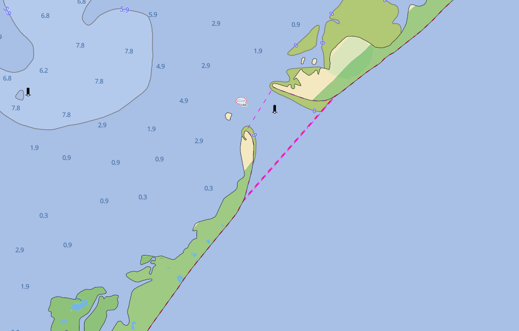 |
| Category 1: Drum Inlet in North Carolina. You will notice that there are no ATONs (aids to navigation) and no soundings shown. The inlet shifts so quickly that trying to mark the channel would be pointless. Installing ATONs would only encourage mariners to use this dangerous inlet, which would be negligent. Inlets like this are not to be used under any circumstance. |
 |
| Category 1: Browns Inlet in North Carolina. If there are no channel markers, stay away. |
 |
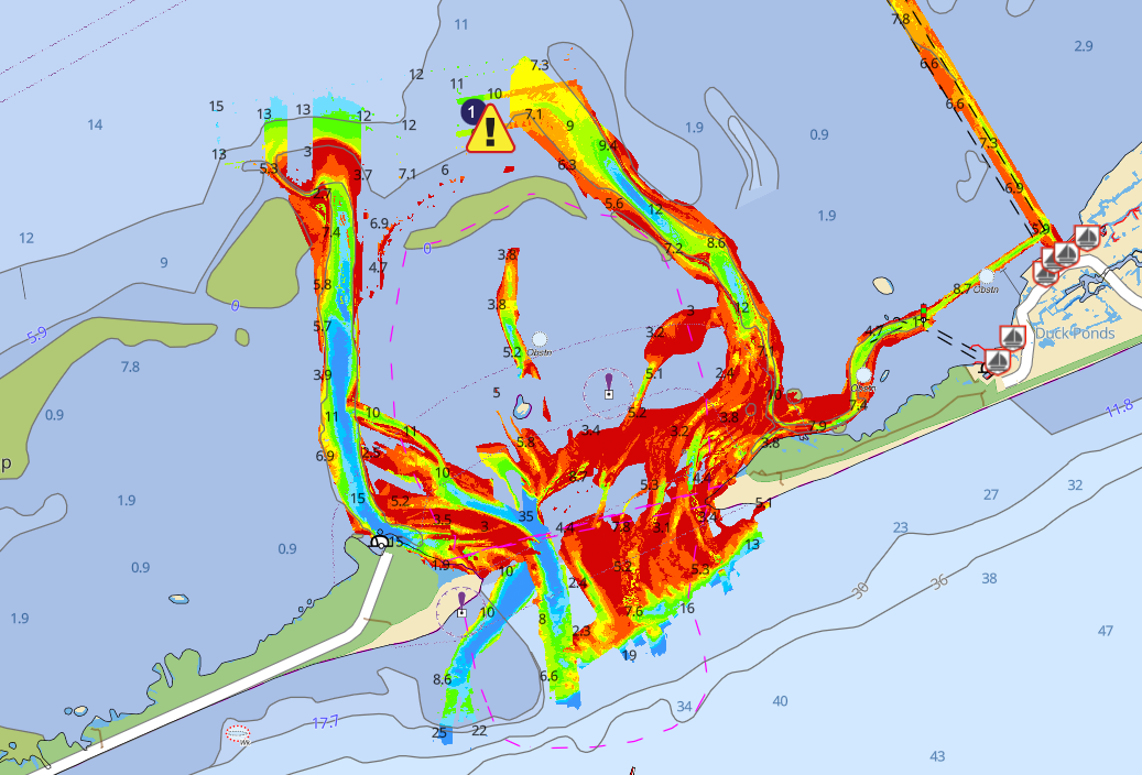
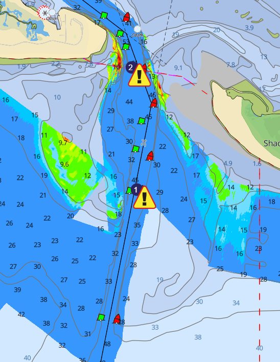
| Category 2: Oregon Inlet: infamous for pulverizing boats, it is probably the most notorious inlet on the entire East Coast. The U.S. Army Corps of Engineers' depth survey data make the approach to the inlet seem easy and straight forward. However, we can guarantee that the actual depth contours in the inlet don’t look like this. Opening toward the northeast means that Oregon Inlet is exposed to the strongest wave action from every passing storm. This image is one snapshot in time of a rapidly moving inlet. Local mariners who use this inlet every day can keep up with the changes to the channel over time. Unless you are a professional mariner from Wanchese or Manteo, stay away. |
 |
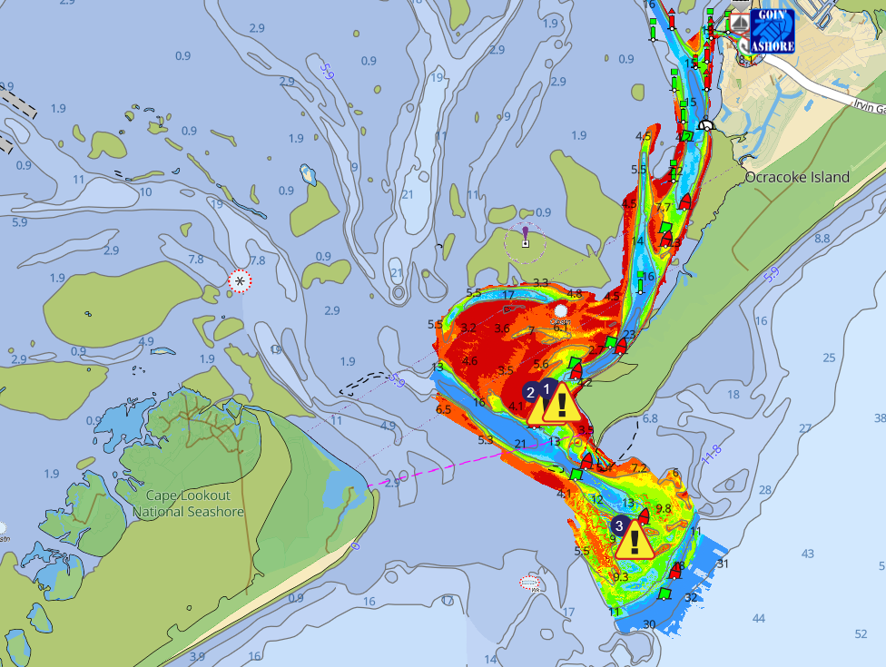
| Category 2: Hatteras Inlet. Note that there are channel markers only in the inner part of the inlet; this is because the outer portion of the inlet changes much more rapidly. Also note in all of these images that the shallowest water is not inside the estuary, but rather in the coastal ocean just outside of the inlet. That's where the real problems exist. |
 | |
|
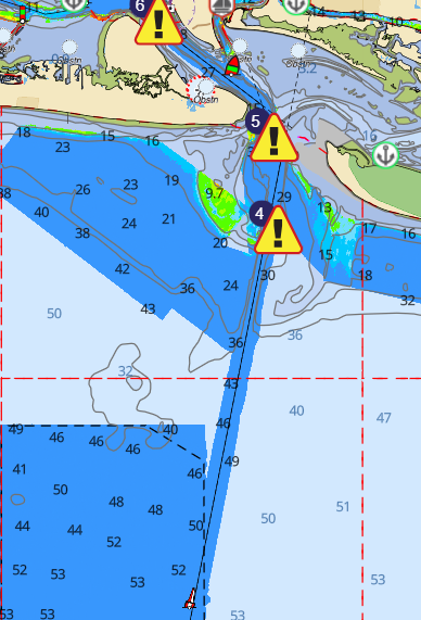 |
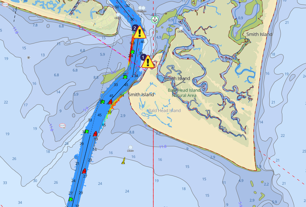
| Category 3: Beaufort Inlet, a deep, wide, well-marked ship channel providing an easy connection between the ocean and ICW (near MM 204). Like any inlet, it can be rough during an onshore wind and ebbing tide. As long as you stay in the channel, you won't run aground. |
 |
| Category 3: A closer look at Beaufort Inlet, one of only two deepwater inlets in North Carolina. The other Category 3 inlet in North Carolina is Cape Fear Inlet. |
 |
| Category 3: Cape Fear Inlet. A deep, wide inlet. The ebb tide can be quite strong, similar to most other inlets. We like to see blue depth contours! |
Conclusion
Returning to inland waters from the ocean via an inlet is probably the most dangerous maneuver you will ever attempt with your boat. Treat the inlets with respect; only use the deep ones that are commercial ship ports and only use them when the weather is settled. If you are in the ocean and the weather becomes rough, the desire to get back into sheltered water will be high. You might be tempted to run into the inlet even though conditions are not favorable, or even to use an inlet that you otherwise would avoid. This is the exact wrong thing to do. If a rising wind has an easterly component, there will likely be large, breaking waves at the inlet. You would probably be better off heading offshore to give yourself some sea room and riding it out. You will be uncomfortable, but you won’t run aground and you will avoid the largest breaking waves, which will be at the mouth of the inlet. If you are in a monohull sailboat and have sufficient sea room, you should consider heaving-to.
Fatigue is another risk factor at inlets. Usually, when you are approaching an inlet from offshore, you will be nearing the end of a passage, or at least at the end of a long day's sail. You will likely be tired. Fatigue clouds your judgement, reduces your awareness of your surroundings, and increases your reaction time. A disproportionate number of the serious accidents suffered by cruising boats takes place at the ends of passages, in shallow water, not out on the open ocean. Making passages offshore is fun. You just need to be honest about your knowledge and skill level, and know where the real risks are.
To Learn More
- ICW Cruising Guide by Bob423 (Facebook group)
- Navigating Inlets of the East Coast USA (Facebook group)
- Inlet ChartBook: Southeastern United States (By Steve Dodge. A bit dated but still relevant)
- NOAA Coast Pilot 4: Cape Henry, VA to Key West, FL (55th Edition, 2023)
- Distances Between Inlets of the East Coast: comparisons of ICW and Offshore routes. (This is a handy tool developed by Ted Arisaka that calculates the distance between any two inlets by both the ICW and offshore routes. Very handy for route planning.)
- Introduction
- Chapter 1: Tips & Tricks
- Chapter 2: Water Levels
- Chapter 3: Avoiding Obstacles
- Chapter 4: Running Aground
- Chapter 5: Bridges
- Chapter 6: Inlets
- Chapter 7: Docking, Anchoring & Mooring
- Chapter 8: Navigation Electronics
- Chapter 9: Weather Basics
- Chapter 10: Typical Weather
- Chapter 11: Environmental Stewardship
- Chapter 12: The Perfect Boat
- Chapter 13: Maintenance
- Chapter 14: Conclusion
- About the Authors
